This Parish Summary is an overview of the large amount of information held for the parish, and only selected examples of sites and finds in each period are given. It has been beyond the scope of the project to carry out detailed research into the historical background, documents, maps or other sources, but we hope that the Parish Summaries will encourage users to refer to the detailed records, and to consult the bibliographical sources referred to below. Feedback and any corrections are welcomed by email to heritage@norfolk.gov.uk
The parish of Burgh and Tuttington is situated in the Broadland district of Norfolk. It lies south of Colby, north of Brampton, east of Aylsham and west of Skeyton. The name Burgh may derive from the Old English phrase meaning ‘mound or hill’. Tutttington may come from the Old English meaning ‘enclosure of Tutta’s people’. Burgh and Tuttington were originally separate parishes, each with their own church before they were combined into a unified parish. Both Burgh and Tuttington have a long history and were well established by the time of the Norman Conquest. Their population, land ownership and productive resources were detailed separately in the Domesday Book of 1086. This document mentions that Tuttington had a mill and that Burgh (next Aylsham) was held by a freewoman called Maerwynn before 1066 and by the King after the Conquest.

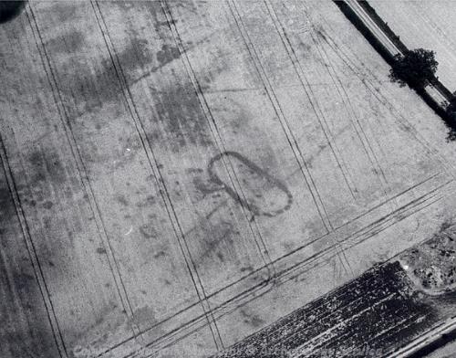
Aerial photograph of a Neolithic long barrow and a possible Neolithic cursus on Stow Heath. (©NCC)
The earliest archaeological site in the parish is a Neolithic long barrow on Stow Heath (NHER
31740). This was identified on aerial photographs that were taken in 1990 and 1996 and a possible Neolithic cursus was also identified in close proximity to the barrow. A large number of prehistoric flint tools have also been found in Burgh and Tuttington. Many of these are of an unspecified date, with various scrapers (NHER
32331), flakes (NHER
25175) and cores (NHER
28181). More precisely dated finds include Mesolithic and numerous Neolithic flint axeheads (e.g. NHER
7543 and
28309). In addition, two more interesting Neolithic/Bronze Age stone implements have been retrieved and these consist of an axe-hammer (NHER
7541) and a knife blade (NHER
44371).
A wealth of evidence for Bronze Age activity has been recorded. The most prominent features are a group of barrows on Tuttington Common (NHER 7545) that were excavated in 1808. This work found burnt bones and a copper alloy palstave nearby. Aerial photography has also identified a possible Bronze Age causewayed enclosure (NHER 36457) to the southeast of Harness Cottage, which lies within the Hall Plantation. Six other possible Bronze Age ring ditches have been found (including NHER 11663, 11664 and 11666) and if these are of this period it suggests significant domestic or ritual activity (through burial).
Fewer Iron Age features have been recorded within the parish. Cropmarks of a possible Iron Age square barrow (NHER 11663) have been noted in a field approximately 500m east of the Old Rectory. Few artefacts from this period have been found although a single terret, a find characteristic of this period, has been found (NHER 33592) along with a worn gold stater coin (NHER 11666).

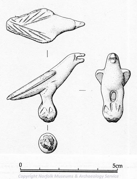
Roman figurine of a bird from Burgh and Tuttington. (©NCC)
During the Roman period there was a settlement (NHER
33592) to the northeast of the parish. This site was identified by the sheer number of Roman pottery sherds, and metal detecting has recovered numerous other Roman finds including the figurine of a bird. The other Roman site is a possible rectilinear enclosure found in close proximity to the settlement (NHER
21834), and as such may relate to it. In addition to these two sites, a number of Roman small finds have been found in the parish. Many of these are mundane items such as pottery sherds (e.g. NHER
7590), studs and nails (NHER
11666), coins (NHER
7546) and brooches (NHER
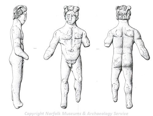
28657). However, a couple of more interesting items have been recovered including a nude male figurine (NHER
30474), a folding razor (NHER
40901) and a bronze sheep’s head (NHER
28493) that may have come from a figurine (although this item may be medieval in date).

Roman nude male figurine from Burgh and Tuttington. (©NCC)
The Saxon period in Burgh and Tuttington is represented by a number of metalwork objects and pottery sherds (NHER
7590). A selection of brooches has been found (NHER
30561 and
33116) including a fine cruciform brooch made from copper alloy (NHER
38150). Of more significance is the 10th century trefoil Viking brooch (NHER
28493) that was found in 1991-92, as such artefacts are quite rare. A range of other finds include an Early Saxon hanging bowl escutcheon (NHER
33592) and cast ring (NHER
28493) along with a Middle Saxon strap end (NHER
50157) and gilt bronze pin-head reused as a mount (NHER
28493).
Both the church in Burgh and the church in Tuttington date to the medieval period. St Peter’s and St Paul’s Church in Tuttington (NHER 7565) is small but notable for a number of Norman features including the round tower and piscine. Much of this church dates to 1450 but some of the current exterior can be attributed to restorations in 1884 and 1912. St Mary’s (NHER 11602) in Burgh is of interest due to its remarkable Early English chancel with blank arcading formed of stiff-leafed capitals on freestanding shafts. Much of the church is in the Perpendicular style but fossilised quoins in the nave may suggest the church has Norman, or even Late Saxon, origins. It has also been speculated that a chapel dedicated to St Botolph (NHER 12864) existed in the parish at this time. The location of this chapel is unclear, with the suggested area of the chapel now under modern housing.
Aerial photographs taken of the Church Lane area of Burgh show the earthworks of square enclosures and the remnants of building platforms (NHER 29497). These features date to the medieval period and suggest that during medieval times the village may have been greater in extent. Sadly, the area in which the medieval village remains are situated is now overgrown which makes it difficult to see the earthworks. Other aerial photographs show that a number of medieval field boundaries/field systems survive across the parish (NHER 11664, 21834 and 24979).
It is also known that Burgh had a hall and watermill situated atop Round Hill during the medieval era (NHER 7544). Only the moats belonging to these two structures remain, although a number of medieval finds have been retrieved including a helmet, the components of wooden and stone bridges as well as numerous medieval pottery sherds.
As one would expect, metal detecting and fieldwalking have recovered a diverse range of metal objects. Several of these objects were items of religious significance, with three lead ampullae (NHER 23835, 33116 and 35038) and a Papal bulla of Urban VI (NHER 40901) being found. Other finds of note include a beautiful cast bronze sword pommel (NHER 28657), a circular mount decorated with an eagle (NHER 24884) and a seal matrix with a fish motif (NHER 40901).
A diverse range of sites and finds date to the post medieval period. A number of sites relating to manufacture and production have been identified including two brickworks (NHER 7538 and 36462). Burgh also had a functioning watermill (NHER 7547) during the late 18th/early 19th century. This mill was still in operation in 1977, and the machinery remained in place until 1983. It was said to have variously produced flour, worstead cloth, animal feed and electricity.
Later in the post medieval period the trade of goods manufactured in Burgh and Tuttington would have been aided by the introduction of canals and railways. The Bure Navigation Canal (NHER 29856) that linked Aylsham to Coltishall was constructed between 1775-78, enhancing trade and communication until it closed in 1928. The Midland and Great Northern Joint Railway (NHER 13581) also ran through the parish after it opened in 1865. Sadly, the whole line is now closed, although some sections survive as paths and various stations, signal boxes, goods sheds remain.
Of course during this era a number of fine buildings were erected, many of which have been deemed as properties of architectural interest. These include the Old Rectory in Tuttington (NHER 12839) which dates to the 17th century and has a Georgian facade and the Old Manor on Wood Lane in Tuttington (NHER 12858) which is of similar date and notable for its parapeted gables with brick tumbling, the rebuilt butt purlin roof and unusual chimneystack. Both Burgh and Tuttington also had halls during the post medieval period. Burgh Hall (NHER 12838) was demolished in 1981. It was a large, red brick 19th century house in Jacobean style. Inside, there was an imitation Jacobean plaster ceiling in the main downstairs room, some good fireplaces and servants' bells. Tuttington Hall (NHER 19473) is still standing and is earlier in date; with an 18th century façade covering a 17th century core. The Hall is characterised by parapeted gables with internal chimneystacks and the dogtooth eaves cornice of the roof.
In terms of post-medieval finds, the majority recovered from the parish are mundane items relating to everyday life. A representative selection could include jettons (NHER 30561), coins (NHER 44744), thimbles (NHER 40901), spurs (NHER 36570), cloth seals (NHER 23835), tools (NHER 11666) and pottery sherds from typical post medieval wares (e.g. NHER 28600).
The most recent archaeological record for the parish dates to World War Two. A set of tank traps (NHER 12860) exists to the south of the Burgh Bridge. These four concrete blocks were intended to block any tanks from fording the river and they formed part of the Bure defensive line (a series of defences running along the course of the river).
Thomas Sunley (NLA) 29 May 2007.
Further Reading
Brown, P. (ed.), 1984. The Domesday Book (Chichester, Phillimore & Co.)
Mortlock, D. P. and Roberts, C. V., 1985. The Popular Guide to Norfolk Churches: No.1 Northeast Norfolk (Cambridge:
Acorn Editions)
Pevsner, N. and Wilson, B. 1999. The Buildings of England, Norfolk 1: Norwich and North-East (London, Penguin)
Rye, J., 1991. A Popular Guide to Norfolk Place Names (Dereham: The Larks Press)