This Parish Summary is an overview of the large amount of information held for the parish, and only selected examples of sites and finds in each period are given. It has been beyond the scope of the project to carry out detailed research into the historical background, documents, maps or other sources, but we hope that the Parish Summaries will encourage users to refer to the detailed records, and to consult the bibliographical sources referred to below. Feedback and any corrections are welcomed by email to heritage@norfolk.gov.uk
Binham, from the Old English meaning ‘homestead belonging to Bynna’, is a large parish in the north of the county, close to the coast.
Settlement in Binham has been continuous since the prehistoric period, and large amounts of Neolithic and later flints have been found scattered throughout the parish, including axeheads (NHER 1877, 2073, 2075, 2212), a Neolithic quern (NHER 15118) and other flint implements, such as scrapers, flakes and blades (NHER 31571). The cropmark of a ring ditch, visible on aerial photographs, is probably the remains of a Bronze Age barrow, overlooking a stream to the west of the parish, and several scatters of prehistoric pot boilers and burnt mounds have been found in the south of the parish (NHER 2076, 2099, 2100, 2101).
Settlement in Binham continued to develop throughout the Roman period. Large amounts of pottery, coins and metalwork (NHER 25464, 40263) have been found by metal detecting in the parish, and the site of a possible Roman villa has been found, along with a ditched Roman field system (NHER 31571). Large amounts of Roman coins, pottery, and building materials have been found in the area immediately around the site of the villa (NHER 24150). The course of a Roman road is also visible as an earthwork (NHER 2087).
Binham was a valuable settlement worth £20 in Domesday Book, and a ‘manor hall’ was listed in the survey, indicating the presence of a substantial manorial residence, probably that of a Saxon thegn. Saxon pottery and metalwork (NHER 24151, 24226, 25464, 31572 etc.) have been found throughout the parish, including several high status finds, including a disc brooch decorated with enamel and garnet (NHER 29339) and an Early Saxon gold bracteate depicting a warrior fighting a beak headed beast (NHER 40776).

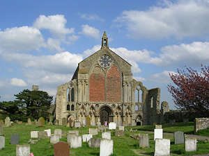
The west front of Binham Priory. (©NCC)
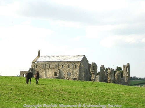
The medieval landscape of Binham is dominated by Binham Priory (NHER
2081), one of the most important survivals of an almost complete medieval monastic precinct. The Priory was founded in the 12th century, and the church is still in use as the parish church of St Mary’s. The ruins of the rest of the monastic complex are an evocative reminder of the austerity, and the excesses, of medieval monastic life, especially when compared with the apparently luxurious lifestyle of some of the inhabitants of Binham in the Roman and Saxon periods. Binham Wayside Cross (NHER
2082) is a medieval stone cross, and one of the best surviving examples in Norfolk. The monks of Binham instituted a fair and a market, which were held on this site from the medieval period until the 1950s.

The ruins of Binham Priory. (©NCC)
Binham has an impressive array of early buildings, including Westgate Cottage (NHER
12743) which contains reused medieval masonry from the Priory, Abbey House (NHER
19886), dating from the 16th century, and the Chequers Inn (NHER
33487), built in the late 16th century, and many others.

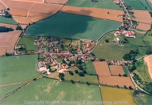
Binham from the air. (©NCC)
The hamlet of Cockthorpe, from the Old Scandinavian meaning ‘an outlying settlement or farmstead' and the Old English 'cocke', which derives from either a family name or from a place 'where cocks are reared'. It is listed in Domesday Book as a tiny settlement, and it never seems to have developed much more. All Saints’ Church (NHER
1888) dates back to the 11th century, and 15th century wall paintings of St Christopher and the Ten Commandments were rediscovered in the 1980s. The earthwork remains of medieval farming have survived on Cockthorpe Common (NHER
41076), showing that this area of the parish was under cultivation during the medieval period.
Langham airfield (NHER 1891), to the north of the parish, has one of only three surviving dome trainers in England. Films of enemy aeroplanes were projected onto the walls of the dome for training gunners during World War Two.
Sarah Spooner (NLA), 17 August 2005.
Further Reading
Brown, P., 1984. Domesday Book; Norfolk (Chichester, Phillimore)
Mills, A. D., 1991. Dictionary of English Place Names (Oxford, Oxford University Press)
Pevsner, N. and Wilson, B., 1997. Norfolk 1: Norwich and North East (London, Penguin)
Rye, J., 1991. A Popular Guide to Norfolk Place Names (Dereham, The Larks Press)