This Parish Summary is an overview of the large amount of information held for the parish, and only selected examples of sites and finds in each period are given. It has been beyond the scope of the project to carry out detailed research into the historical background, documents, maps or other sources, but we hope that the Parish Summaries will encourage users to refer to the detailed records, and to consult the bibliographical sources referred to below. Feedback and any corrections are welcomed by email to heritage@norfolk.gov.uk
Runcton Holme is a moderately sized parish in the west of Norfolk. It lies to the north of Stow Bardolph and to the south of Watlington. The exact origins of the name Runcton Holme are not clear. However in Old English Runcton means ‘settlement at the bridge’ and Holme means ‘small island or river meadow’. This suggests a riverside settlement near to a bridge, which would make sense as the River Great Ouse runs through Runcton Holme. The parish has a long history and was certainly well established by the time of the Norman Conquest, its population, land ownership and productive resources being extensively detailed in the Domesday Book of 1086. This document reveals that before 1066 the lands were under the jurisdiction of the Abbot of St Edmund.
The earliest find recorded from the parish are flint flakes (NHER 2398) dating to the Mesolithic period. The majority of prehistoric finds date to the Neolithic period and take the form of flint tools. Types identified include axeheads (NHER 2403, 2406 and 34454), a chisel (NHER 11402), a sickle (NHER 2404) and a blade (NHER 2400). Additionally, a few sherds of Neolithic pottery (NHER 14359) were recovered and these are noteworthy because wares from this period comprise the earliest pottery ever made.
The records for the Bronze Age yield a more diverse set of finds as well as a few sites. A possible Bronze Age ring ditch with associated linear marking (NHER 16145) was identified by aerial photography in 1977 close to Chiswick’s Farm. Going further back in time, antiquarians found two small, unburnt urns containing human remains (NHER 2409) at a site north of the village playing fields. These finds were felt to date to the Bronze Age but no associated barrow or cemetery site was found. Along with characteristic Bronze Age finds such as axeheads (NHER 44101) and a palstave (NHER 22265) was a jet bead (NHER 2408). Jet artefacts often served a funereal purpose, and this find along with the cremation urns and ring ditch show burial activity and some sort of investment in the area during this period.
The first definitive occupation site in Runcton Holme is Iron Age in date. A Romano British farmstead and saltworks (NHER 2397) existed north of School Road in the Garbold’s pit area. This was identified through the concentration of Iron Age pottery sherds and artefacts, which included crucible fragments and loomweights. This site continued in use into the Roman period judging by the kiln furniture found here, so it was obvious a good location for settlement and manufacturing. Apart from an Iron Age spindle whorl and loom weight (NHER 13368) retrieved from Wallington Park, the rest of the finds from this era consist of rather mundane pottery sherds (NHER 2398, 2410 and 2411). However, before moving on to the Roman period it is worth mentioning that a wooden boat built from oak (NHER 2394) was found in peat near to a relief channel of the Great Ouse. Although this fell apart after recovery it was felt to predate the Roman fen road.
In addition to the Romano-British farmstead (NHER 2397) mentioned earlier, two Roman pits have been found in Runcton Holme. One of these appears to be a simple rubbish pit and was filled with pottery sherds (NHER 2405). In contrast, the fill of the other pit was enclosed by four wooden posts and contained pottery sherds, animal bones and other debris (NHER 2413). The nature of this structure and its close proximity to a round house suggest this may have been a Roman privy! A decent selection of Roman finds have been recovered from the parish, many of them found through metal detecting. The most interesting of these finds were an iron halberd head (NHER 2398), small votive axehead (NHER 33872) and set of lead weights (NHER 29718). We know that the farmstead (NHER 2397) was occupied during this period and these varied artefacts may show activity linked to the military and religion in this era.
Little evidence of the Saxon period appears in the archaeological records for Runcton Holme. Apparently St Margaret’s Church in the deserted medieval village of Wallington (NHER 2421) had Saxon origins. Prior to 1868 a Saxon cremation urn containing human bones (NHER 2414) was reportedly found in the parish but the exact location of its discovery is unknown. Other finds found mainly comprise pottery sherds (NHER 11999) and brooches (NHER 33872 and 44111), although the fragments of a couple of nice cruciform examples (NHER 44111) merit a mention. Metal detecting east of St James’ Church also found the fragments of a Late Saxon bridle (NHER 28741).
Runcton Holme is of particular interest to those studying the medieval period as it contains not one, but two deserted medieval villages! The first at Thorpland (NHER 2401) is attested to by documentary sources and finds recovered from here in 1964. These finds included medieval and later sherds, human skeletons, coffin nails, a paten and chalice, lead fragments and building materials. The site of the village’s abandoned church of St Thomas (NHER 2415) has been also identified. This church was still standing in 1419, ruinous by about 1500 and was transformed into a barn in 1612. The reasons for abandonment are not clear but it is likely that a dwindling population was unable to maintain a settlement here and consequently relocated. The other village at Wallington has already been briefly mentioned. Aside from the church tower all the other structures and enclosures relating to the former settlement are only visible as cropmarks. Again the reasons for depopulation are not clear but there are suggestions this it was depopulated by Judge Gawdy at some point in the medieval period to make way for a park! There is little evidence to suggest that this park was Wallington Park (NHER 30527), as this does not appear on documents until 1797. However, Stow Hall Park (NHER 30524), associated with the now demolished Stow Hall, was a deer park at the end of the medieval period before being heavily altered in the post medieval period to convert it into landscaped gardens.
The only medieval church still completely standing is St James’ (NHER 2431). Much of the architecture of this church dates to the Norman period, including the tower, chancel arch and the south entrance doorway. Later additions include the charming 16th century red brick porch and the building was re-roofed and re-pewed in 1845. Visitors to this pleasant church can view 18th century memorials dedicated to clerics and parishioners alike. Aerial photography also records traces of medieval farming in the form of earthworks left over from ridge and furrow field systems (NHER 25386 and 25387).

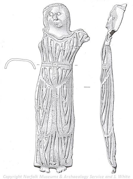
A medieval Christ figure from Runcton Holme. The figure was once attached to a crucifix. (© NCC and S. White.)
Some of the most impressive artefacts found in Runcton Holme are medieval. A remarkable 12th century enamelled figure of Christ from a Limoges crucifix (NHER
37303) was recovered from a sugar beet field. Metal detecting uncovered a seal matrix decorated with an elaborate flower (NHER
28741) and a gilt and enamelled medallion showing the arms of France Ancient (NHER
43135). Along with these fine objects, a 15th/16th century pax board (NHER
24193), used to convey the kiss of peace to the faithful at church, is held by the St Peter Hungate Museum.
The magnificent Wallington Hall (NHER 2425) is the most prominent post medieval building in Runcton Holme. Although it was built in the early 16th century (medieval to post medieval transitional period) it had a cross wing added to the north in Elizabethan times and underwent alterations in the 18th century and was totally restored in 1918. The hall is mainly built from brick and features an impressive entrance front with arcaded turrets and diaper work to the side and battlements above. Inside, the hallway has 16th century panelling and fine ionic pilasters but the dais staircase is only original at the top, with the majority of it dating to 1790. As is standard it sits within Wallington Park (NHER 30527), which was landscaped heavily in the 19th and 20th century but also features an earlier 16th/17th century walled garden.

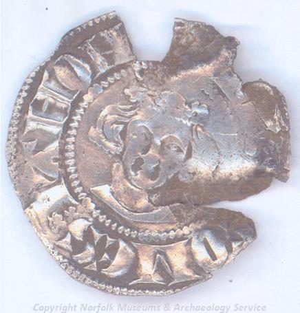
A John of Avesnes penny, a sterling imitation, from Runcton Holme. (© NCC)
St Andrew’s church (NHER
2432) in South Runcton also dates to this period having been erected in 1838 by John Brown of Norwich to replace the Norman church that had fallen into ruin. The chancel arch, although heavily restored, is an original feature. Other features include big pilasters to the west front and between the nave windows. Other buildings from this period listed as structures of archaeological interest include Manor Farm (NHER
20419) and Number 29 (NHER
46855), both on Downham Road. The East Anglian Railway line from Ely to King’s Lynn (NHER
13594) that opened in 1847 also runs through Runcton Holme.
In general the artefacts that have been recovered and dated to this period are unexciting. However, a nice signet ring engraved with a conjoined A and X in the centre (NHER 25957) was found in the vicinity of St James’ Church (NHER 2431).
The most recent archaeological record for the parish concerns the crash site of a World War Two Lancaster bomber (NHER 18281) to the southwest of Bell’s Drove. There are few details about this crash but it is believed to have occurred in 1940 and been the result of an accident.
Thomas Sunley (NLA), 7 February 2007.
Further Reading
Brown, P. (ed.), 1984. The Domesday Book (Chichester, Phillimore & Co.)
Mortlock, D. P. and Roberts, C. V., 1985. The Popular Guide to Norfolk Churches: No.3 West and South-West Norfolk (Cambridge, Acorn Editions)
Pevsner, N. and Wilson, B., 1999. The Buildings of England, Norfolk 2: North-West and South (London, Penguin)
Rye, J., 1991. A Popular Guide to Norfolk Place Names (Dereham, The Larks Press)