This Parish Summary is an overview of the large amount of information held for the parish, and only selected examples of sites and finds in each period are given. It has been beyond the scope of the project to carry out detailed research into the historical background, documents, maps or other sources, but we hope that the Parish Summaries will encourage users to refer to the detailed records, and to consult the bibliographical sources referred to below. Feedback and any corrections are welcomed by email to heritage@norfolk.gov.uk
The parish of Ringland is situated in the Broadlands district within the valley of the River Wensum. It is notable for its hilly terrain with the Ringland Hills featuring on a painting by Alfred Munnings; an artist famous for his paintings of horses. It lies to the north of Easton and Honingham and to the south of Attlebridge and Morton on the Hill. The name Ringland may originate from the Old English phrase meaning ‘the newly-cultivated land of Rymi’s people’. The parish has a long history and was certainly well established by the time of the Norman Conquest, its population, land ownership and productive resources being detailed in the Domesday Book of 1086. At this time it seems to have been a moderately small parish, with a value of ten shillings.

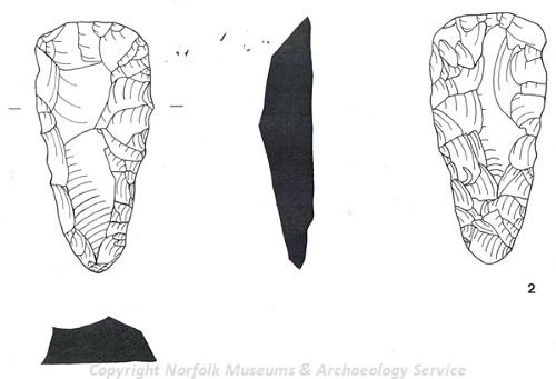
A Neolithic flint axehead roughout found at Ringland. (© NCC)
The vast majority of the archaeological records for Ringland relate to the prehistoric period. These records include information on a number of important sites, relating to both occupation and lithic production. Two flint mines are recorded (NHER
7798 and
33258) although their states of preservation differ quite markedly. The Ringland Hills site (NHER
33258) features a deep conical pit filled with flint nodules but has been damaged recently by mountain biking. However, the other site (NHER
7798), which was subject to excavations very early in the 20th century, has survived better and over the years has yielded finds such as flint axehead roughouts, a hammerstone and a pick/chisel. Both mines date to the Neolithic period and suggest fairly intensive exploitation of the stone resources provided by the rugged hills here. Of equal interest is the possible prehistoric settlement site (NHER
13163) identified on a plateau amongst the Ringland Hills. Here, a prehistoric floor surface was uncovered at the bottom of a gravel pit with flint pieces comprising flakes, scrapers, cones, planes and a single axe laid on top. To the southwest of this floor surface a number of pits containing charcoal and yet more flints were recorded. Perhaps this was an occupation site inhabited during periods of flint working in these hills.
Over forty prehistoric finds have been recorded, and due to this wealth of artefacts only a flavour of the items found will be provided here. The earliest of these artefacts come from the Palaeolithic era, with the most glamorous find proving to be a flint handaxe dating to the Acheulean part of the Palaeolithic period (NHER 14308). A large flint blade dating to the Palaeolithic was also found to the south of the Slade Hills (NHER 21013), again showing utilisation of the hilly terrain by the early inhabitants of the parish. Other finds of a similar date have been supposedly been found in Ringland (NHER 7797 and 12452) but we lack proof that these assertions are correct. The Mesolithic period has only one find noted, a retouched flint blade found during the erection of a fence post in 2002 (NHER 37435). As is typical it is the Neolithic period of prehistory that is best represented, aided by extensive fieldwalking surveys across the parish that have documented many of these finds. A diverse selection of Neolithic flint tools have been found and these comprise, amongst others, of a scrapers and a saw found to the northeast of Church Farm (NHER 24022), a flint pick from ‘Rectory Field’ (NHER 14026) and an end-polished adze retrieved from an unknown location (NHER 14846). Some of the other more captivating artefacts include a thin tanged flint arrowhead from the north side of Royal Hill (NHER 15027) and a leaf arrowhead (NHER 14845), and polished axehead collection (NHER 15736) from unspecified locations.
Sadly, there are few definitive records to illuminate the Bronze and Iron Age in Ringland. A Bronze Age round barrow (NHER 7803) was identified to the east of Blackbreck Plantation in 1950. However, this mound only produced a single sherd of Early Bronze Age pottery and cannot be readily studied now that agricultural ploughing has so heavily eroded it. Nothing readily identifiable with the Iron Age has been found in Ringland, a fact that might be explained by the limited quantity of metal detection that has been undertaken here. When looking at this deficit of evidence it is possible of course that some of the flint pieces loosely assigned a prehistoric date could date to the Bronze or Iron Ages (e.g. NHER 18043 to 18058).
The most important Roman archaeology in the parish is the site of a villa on Royal Hill (NHER 11711). The presence of linear enclosures and ditches were observed on aerial photographs taken in 1976 and a later flyover in 1980 conclusively established the features as a villa. On the ground here a number of Roman pottery sherds, including fragments of samian and greyware, were retrieved. Similar pottery sherds turn up elsewhere on Royal Hill (NHER 23830) as well as further away (NHER 18043). Additionally, a couple of Roman brooches have been found by metal detecting: a disc type example from the foot of Cobbs Hills (NHER 22916) and an incomplete copper alloy example from Low Common (NHER 22644). Fifteen Roman coins were found together near to the Easton Reeds (NHER 17459) and these were a mix of copper alloy and silver pieces. Saxon artefacts from Ringland take the form of an unusually decorated strap end (NHER 20014), bronze plaque with animal head ornamentation (NHER 24553) and cruciform brooch fragment with a human face adorning it (NHER 34371).
The only medieval building that is still standing is St Peter’s Church (NHER 7820). This pleasant church is sited atop a hill to the west end of the village. It dates mainly to the 13th and 14th centuries with Perpendicular architecture. The interior is far more impressive than the exterior however, with Mortlock and Roberts writing: ‘Ringlang roof – so small, so compact, is simply and inevitably beautiful’. Unusually, this church also contains many stained-glass windows featuring full-scale figures as well as fine 17th century memorials. All in all this adds up to a place well worth a visit! Other than ubiquitous medieval pottery sherds (NHER 15184, 19271, 23830, 24021 and 28420) finds from the medieval period include a lead Papal bull of Alexander VI (NHER 28872) and a couple of medieval coins (NHER 34371 and 36985), one of which was a silver penny of Edward I (NHER 36985).

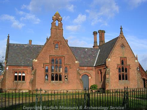
Old School, Ringland. (© NCC)
A number of post medieval buildings have been investigated in Ringland. Two of the most interesting of these are the Old Laundry House (NHER
33259) and the Old School (NHER
12605). The Old Laundry House is a characterful 17th century brick house with the addition of Jacobean styling in the 19th century. Whereas the Old School is a splendid red brick construction dating to 1873 and similar to other schools of this date in East Anglia, including the exclusive Moreton Hall school in Bury St Edmunds. Examples of fine 17th century rural farmhouses are also present here. The barns at Pit Farm (NHER
12602) feature chequered brickwork and thatched roofing, while the Georgian farmhouse behind is in a decent state of preservation. A threshing barn (NHER
20968) at Low Farm serves as a reminder of the agricultural heritage of the parish, with the brick threshing floor and small winnowing door to the northeast being original features. Other such buildings have suffered more damage with the long timber-framed barn at Manor Farm (NHER
13767) lying derelict and under the threat of demolition.
There is also limited evidence of manufacturing and production being undertaken in Ringland at this time. The remains of a post medieval lime kiln near to ‘Limekiln Wood’ (NHER 16992) were reported in 1960 but more recent attempts to find it have proved unsuccessful. Information from 18th/19th century maps also shows that there was a windmill here at this time. According to records this was last used in 1857 and demolished in 1859.
The most recent archaeological records concern World War Two structures, with two being noted within the parish. The first of these is a Home Guard Shelter (NHER 32489) located in a field near to Costessey Lane. It was likely associated with the roadblock on bridge over the River Wensum in this area. The other entry details an earthen ramp (NHER 32148) used during this period for training in driving vehicles onto landing craft. This particular feature was visible on 1993 aerial photographs.
This concludes the overview of Ringland parish. As readers will see, the majority of the archaeology is from the prehistoric period but there are a number of important later features such as the Roman villa on Royal Hill (NHER 11711), medieval St Peter’s Church (NHER 7820) and the 19th century school building (NHER 12605) that are worth considering. The individual records can be accessed for further information on any of the finds and sites mentioned here, and this is the appropriate course of action for interested individuals.
Thomas Sunley (NLA), 15 January 2007.
Further Reading
Brown, P. (ed.), 1984. The Domesday Book (Chichester, Phillimore & Co.)
Mortlock, D. P. and Roberts, C. V., 1985. The Popular Guide to Norfolk Churches: No.2 Norwich, Central and South Norfolk (Cambridge, Acorn Editions)
Pevsner, N. and Wilson, B., 1999. The Buildings of England, Norfolk 2: North-west and South (London, Penguin)
Rye, J., 1991. A Popular Guide to Norfolk Place Names (Dereham, The Larks Press)