This Parish Summary is an overview of the large amount of information held for the parish, and only selected examples of sites and finds in each period are given. It has been beyond the scope of the project to carry out detailed research into the historical background, documents, maps or other sources, but we hope that the Parish Summaries will encourage users to refer to the detailed records, and to consult the bibliographical sources referred to below. Feedback and any corrections are welcomed by email to heritage@norfolk.gov.uk
Ringstead is a moderately sized parish situated in the northwest of Norfolk, near to the coast. It lies to the north of Sedgeford and to the south of Holme next the Sea. The name Ringstead is believed to derive from the Old English meaning ‘circular settlement’ or ‘place with stone circles’. The parish has a long history and was certainly well established by the time of the Norman Conquest, its population, land ownership and productive resources being detailed in the Domesday Book of 1086. A notable feature about the entries for Ringstead is the fact that a mill is mentioned.
The earliest site of human activity is a Mesolithic flint-working site (NHER 1325) 300m west of Chapel Lane. This site was identified because the scatter of flint pieces and working debris that were recorded here were characteristic of prehistoric lithic production. A similar flint-working site (NHER 1327) was located east of the Geddings Cottages on Holme Road, but this one was felt to be later in date, from the Neolithic period. The possible prehistoric ridgeway running east to west along the line of the Ringstead and Holme next the Sea, locally known as Green Banks (NHER 1338), completes the selection of prehistoric sites and features. Of course, a number of prehistoric finds have been retrieved from various places across the parish. Quite a few of the Neolithic flint flakes, scrapers and cores were discovered by systematic fieldwalking by the Norfolk Archaeological Unit in 1989 (see for example NHER 25186-25200). Other finds include Neolithic flint axes (NHER 1326 and 1329), an axe hammer (NHER 11998) and an arrowhead (NHER 1328).
As we move into the Bronze Age several ring ditches (NHER 12835 and 35559) and barrows (NHER 12836 and 29833) have been identified from aerial photographs. Two of these features (NHER 12836 and 35559) lie in close proximity to the south of the village, so perhaps this was an important focal point for Bronze Age activities. Metal detecting has recovered a small selection of Bronze Age finds, which included several socketed bronze axeheads (NHER 30113 and 30133) – one of which had unusual markings (NHER 30133) and flint scrapers (NHER 16376). Further fieldwalking and metal detecting may uncover more finds from this era, as the barrows/ring ditches promise more archaeology than is currently on record.

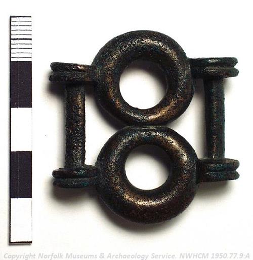
An Iron Age copper alloy strap union found in a hoard at Ringstead. NWHCM 1950.77.9:A (© NCC)
The most exciting Iron Age find is that of a horse harness hoard (NHER
1331), found in 1950 very close to the Green Bank ridgeway (NHER
1338). At the time of discovery it was felt to be the chariot burial of one of Boudicca’s chieftains but this link has never been substantiated. This hoard comprised a collection of bridle-bits, bronze plates, rivets, a clasp and a strap union and certainly represents a significant Iron Age deposition. There are only a couple of other Iron Age items from Ringstead, including a silver coin of the Iceni tribe (NHER
28478) and a mini terret (NHER
29025).
Two Roman sites have been identified through cropmarks visible on aerial photographs. A number of rectilinear enclosures, cut by the Ringstead to Docking road, have been noted. Their form and the presence of Roman pottery sherds indicate the possible presence of a farmstead at this location (NHER 43352). Another probable Roman enclosure (NHER 26923) has been recorded just to the north of Ringstead Common, with finds of Roman pottery and the presence of a ‘clavicula’ type entrance to the enclosure suggesting this date. Ploughing to the east of Peddar’s Way in the south of the parish (near Church Farm) unearthed several Roman refuse pits (NHER 1586) filled with contemporary pottery sherds, roof tiles and part of a military belt mount. It is possible that these pits relate in someway to this Roman way. Along with the typical finds of coins (NHER 16376 and 45408) and pottery sherds (e.g. NHER 25872) were a couple of more impressive finds. The best of these was an iron-socketed spearhead (NHER 11304) found on the Ringstead Downs to the west of the village, but several fine Dolphin (NHER 29401 and 29197) and Trumpet head (NHER 29401 and 30133) brooches have also been found.
The Saxon round tower, which was once part of St Peter’s Church (now ruinous), is the earliest standing monument in the parish and the clearest indicator of a Saxon presence here. Although only a few artefacts from this period have been found, those we do have are quite unusual. A Viking mount from a harness box (NHER 29197) and a Saxon key handle of Viking design (NHER 29902) represent rare and exciting finds. More characteristically local Saxon items have also been recovered like a lead spindle whorl (NHER 28478), strap fittings (NHER 44069) and cruciform brooch (NHER 11304). Additionally, sherds of Middles Saxon Ipswich Ware and Late Saxon Thetford Ware have been found at sites dotted across Ringstead.

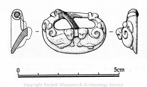
A medieval buckle from Ringstead. (© NCC)
The medieval period in Ringstead is one that is both interesting and more fully served by archaeological records. The first port of call when considering this era is St Andrew’s Church (NHER
1345). It was built in the 13th/14th century, although the exterior was extensively restored. The north side is particularly foreboding as carved demonic animals guard the guttering, and a huge chimneystack is situated to the northeast corner competing with the almost baronial tower. In contrast the interior is somewhat simpler affair, although the floral piscina still catches the eye. The other medieval church: St Peter’s (NHER
1344) served Greater Ringstead but is now ruinous (as mentioned earlier) having undergone two demolition phases in 1771 and 1792. A medieval chapel dedicated to St Bride (NHER
16563) was also recorded on a document of 1653, but no traces of this building remain.
At this point several manor houses were in existence, with a map of 1690 indicating a Bardolf Manor (NHER 28261) and manor house on the site now occupied by Hall Farm (NHER 25082). Agricultural activities were also key in this period with aerial photography showing the remains of several medieval field systems (NHER 25346, 30715, 26892, 26888 and 43351) in the parish. The possible medieval road (NHER 43417) located here may have helped with the transportation of farmer’s goods to market. Of the many medieval objects found in Ringstead the most noteworthy comprise a lead Boy Bishop token (NHER 29401), a buckle (NHER 44097), a harness pendant with a central rosette and fleur-de-lis decoration (NHER 30558) and a bronze seal matrix (NHER 29985) with a French inscription that reads ‘I am a nuisance’!
Understandably remains from the post medieval period are the most obviously evident, as a number of fine buildings in Ringstead originate from this period. The High Street in particular has several such buildings and visitors should take note of the four picturesque 18th century cottages that number 20-26 (NHER 47098). On the same street is the impressive Gin Trap Inn (NHER 38118) which dates to the around 1700 but has later 19th century detailing. The adjacent car park also features a set of post-medieval stocks (NHER 17136) that have survived in their original location here, not having being brought to the pub so as to fit in with the other rustic memorabilia here. The brick built vicarage, now known as the Old Rectory (NHER 20136), with its massive external chimneystack also adorns this section of the village. Further away from the village centre are a number of timber-framed farmhouses and converted barns (see for example NHER 47099 and 46865), perhaps the archetypal buildings for a rural Norfolk parish. Hunstanton Park (NHER 30464), formerly a medieval deer park, was greatly enhanced during the 17th and 19th centuries producing the landscape visible today.
A couple of structures relating to industry and production are recorded in Ringstead. A lime kiln (NHER 14995) was recorded to the southwest of Courtyard Farm by a map of 1769. A circular depression marks where the kiln once stood but a wood now covers this area. Two post medieval windmills were also recorded on the site of the modern Mill Farm, set a short distance back from the Peddars Way North road. One of these mills was converted into a tower mill in 1840 and subsequently into a house in 1927 (NHER 1343). This particular mill was an unusual example accommodating six sails, shown by studying the metal cap atop the six-storey brick tower.
It would be remiss not to mention a few of the post medieval finds recovered from the parish. A diverse selection of objects has been recorded including an enamelled and decorated knife handle (NHER 29025), a thimble (NHER 31617) and sewing ring (NHER 37579).
Following the post medieval period there are relatively few archaeological sites and finds recorded. According to the Norfolk and Suffolk Aviation Musuem a World War One airship station (NHER 13624) was located within Ringstead. However, all attempts to date to determine the exact location of this facility have failed. This mystery site represents the most recent marker of activity in the parish as no World War Two or Cold War defences or artefacts have been logged.
Thomas Sunley (NLA), 26 January 2007.
Further Reading
Brown, P. (ed.), 1984. The Domesday Book (Chichester, Phillimore & Co.)
Knott, S., February 2006. ‘St Andrew, Ringstead’. Available:
http://www.norfolkchurches.co.uk/ringstead/ringstead.htm. Accessed: 26 January 2007
Knott, S., February 2006. ‘St Peter, Ringstead’. Available:
http://www.norfolkchurches.co.uk/ringsteadruin/ringsteadruin.htm. Accessed: 26 January 2007
Mortlock, D. P. and Roberts, C. V., 1985. The Popular Guide to Norfolk Churches: No.3 West and South-West Norfolk(Cambridge, Acorn Editions)
Neville, J., 2006. ‘Ringstead towermill’. Available:
http://www.norfolkmills.co.uk/Windmills/ringstead-towermill.html Accessed: 26 January 2007
Pevsner, N. and Wilson, B., 1999. The Buildings of England, Norfolk 2: North-west and South (London, Penguin)
Rye, J., 1991. A Popular Guide to Norfolk Place Names (Dereham, The Larks Press)