This Parish Summary is an overview of the large amount of information held for the parish, and only selected examples of sites and finds in each period are given. It has been beyond the scope of the project to carry out detailed research into the historical background, documents, maps or other sources, but we hope that the Parish Summaries will encourage users to refer to the detailed records, and to consult the bibliographical sources referred to below. Feedback and any corrections are welcomed by email to heritage@norfolk.gov.uk
Hilborough is a large parish in Breckland, and incorporates the former parish of Bodney. Much of the land is now owned by the Ministry of Defence. The Tithe map illustrates the wide area of heathland and brecks that formerly extended over the parish, now enclosed and ‘improved’.
The earliest archaeological find is a Palaeolithic flint implement (NHER 5011). Other prehistoric flints (NHER 5019, 11908, 24609 to 24613, 24615, 24618, 24623 and 24674) including flakes (NHER 5024 and 24625) and scrapers (NHER 25326 and 28864) have been collected during fieldwalking. A prehistoric pot boiler site (NHER 24616) has also been identified. Mesolithic flints (NHER 5057) including three tranchet axeheads (NHER 13326), a Mesolithic to Early Neolithic flint blade (NHER 34535) and Neolithic flints (NHER 2704, 5012, 5013, 5014 and 37275), including an axehead (NHER 15083), an adze (NHER 2703), scrapers (NHER 5015 and 24614) and a chisel (NHER 5017) have also been found. In the 1940s a long earthwork mound stood close to the parish boundary, near Bodney Camp, but the feature has since disappeared. The mound may have been a Neolithic long barrow (NHER 22725).
In 1930 workmen discovered a Beaker burial and a Beaker pottery vessel (NHER 5018) with a handle near Smugglers' Road in Bodney. Fieldwalking in the parish has revealed a Late Neolithic to Early Bronze Age occupation site (NHER 21055), although the nature of that occupation is uncertain. Prehistoric flints and a fragment of Late Neolithic to Early Bronze Age pottery have been found on the site, which lies on high ground close to the South Water Ford. A Neolithic to Bronze Age barbed and tanged arrowhead (NHER 2707), a scraper (NHER 35868), other flint implements (NHER 35867, 35866, 35865, 36264 and 36263) and Late Neolithic to Early Bronze Age pottery (NHER 24617 and 25326) have been collected during fieldwalking.

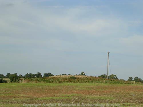
A Bronze Age round barrow that survives as an earthwork at Hilborough. (© NCC.)
Several Bronze Age barrows (NHER
5025,
5026,
5027,
5057,
23874,
23877,
24730 and
35830) survive as upstanding earthworks, and two ring ditches (NHER
35503) are visible as cropmarks on aerial photographs. One of the barrows, Dead Man’s Hill (NHER
5026), was excavated in 1901 and a Bronze Age cremation was found. A Bronze Age spearhead (NHER
2708) has been found in the parish.
Fieldwalking has revealed a concentration of Iron Age pottery, probably the site of a settlement (NHER 21055), on the same site as a Late Neolithic to Early Bronze Age occupation site (NHER 21055). Iron Age pottery (NHER 24618, 24624, 24731 and 24732) and coins (NHER 33364 and 33614) have been found during fieldwalking and metal detecting, as well as an Iron Age or Roman blank for making a brooch (NHER 35277).
The site of a small Roman settlement (NHER 2706) has been recorded near the Blackwater Ford. In 1936 a Roman pit (NHER 5020) was discovered close to Smuggler’s Road, containing Roman pottery and animal bone. The road running along the southern boundary of the parish has been interpreted as a possible Roman road (NHER 5072). Roman pottery (NHER 5019, 24612, 24613, 24615, 24617, 24623, 24626, 35622, 35867, 36263 and 37235) has been found scattered throughout the parish, although none of the pottery was found in concentrations suggesting the presence of a settlement site. However, the distribution of Roman pottery does suggest that cultivation once extended over a wide area, including the driest areas of soil. A Roman quern was found in Hilborough churchyard (NHER 2709), and metal detecting has recovered a number of coins (NHER 33223, 33364, 33614, 34535 and 40983) and metal finds including brooches and a silver finger ring (NHER 33364, 33614, 33748, 34261 and 35277).

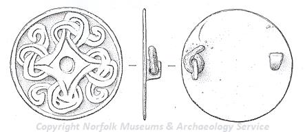
A 10th century Borre style disc brooch from Hilborough. (© NCC.)
Hilborough comes from the Old English meaning ‘stream or enclosure of a woman named Hildeburh’. Bodney also has its origins in Old English and means ‘Beoda’s island’. In this case ‘island’ refers to an area of ‘dry ground in marsh’. Fieldwalking and metal detecting have recovered Early Saxon pottery (NHER
2710,
5019 and
28106) and Middle Saxon pottery (NHER
5019,
5044 and
35622), a Middle or Late Saxon hooked tag (NHER
33223), Late Saxon pottery (NHER
5019,
24609,
24610,
24611 and
25326), a Late Saxon stirrup mount (NHER
33364), a strap end (NHER
35277) and a silver Viking coin (NHER
36821).

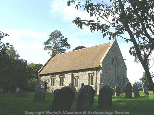
St Mary's Church, Bodney (© NCC.)
In 1086 Bodney was held by William of Warenne and Ralph of Tosny, but the main holding was in the hands of Hugh of Montfort. Bodney is recorded as having woodland and at least two mills. The Domesday Book does not record a church, although it seems likely that there was a church in existence during the Late Saxon period. St Mary’s Church (NHER
5022) in Bodney is now virtually isolated, and the village of Bodney itself has almost disappeared. To the north of the church fieldwalking has revealed what may have been the original core of the village (NHER
5021). The site may have its origins in the Middle Saxon period, if not earlier, and was certainly occupied during the Late Saxon and medieval periods. Pieces of fired clay daub from a building have also been found on the site. St Mary’s Church (NHER
5022) is a medieval parish church, incorporating some Late Saxon carved stonework. To the east of the church are the foundations of a building, possibly an earlier church.
To the north of the church, close to the former parish boundary between Bodney and Hilborough, are the earthworks of a medieval moated site (NHER 5042). One side of the moat is a former channel of the Watton Brook. To the east of the moat is a medieval hollow way, probably a street leading from the main village, and another linear earthwork may be a lane leading to the stream. There are also earthworks of two possible enclosures. These earthworks all end abruptly at a hedge bank, and the field is called ‘Oak Yards’ on the Tithe map. The site is probably one of the three medieval manors of Bodney.
Bodney Hall (NHER 5044) was probably built on the site of a medieval manor house. The Hall itself may have dated to the 16th century and was surrounded by a medieval moat, one arm of which survives. The Hall was demolished in the 19th century and the site is now marked by the earthworks of the gardens and buildings. To the south are the earthworks of three medieval fishponds, probably associated with the manorial site. A rectangular earthwork (NHER 29756) is visible on aerial photographs to the south of the site of the Hall, close to the stream. The feature is probably a medieval to post medieval retting pond or sheep dip. Bodney Hall Farm (NHER 25078) is a 16th century timber framed house with a queen-post roof and elaborate internal mouldings.
During the medieval period the landscape of Bodney was dominated by a medieval rabbit warren (NHER 31771), which was held by the Priory of Thetford. The straight parish boundary between Bodney and Threxton is marked as the 'old bank' on the Tithe map, and this may have been the boundary of the warren. The remains of the warren lodge stand in the centre of the former warren.
In 1086 Hilborough was entirely in the hands of William of Warenne. Twenty-two villagers, ten smallholder and six slaves are recorded in the Domesday Book, and the holding was worth £7.
All Saints’ Church (NHER 2718) in Hilborough has an early 14th century chancel and a 15th century tower. Lord Nelson’s father and grandfather were rectors of the church, and several of Nelson’s relatives, including his brothers and sister, are buried in the church. St Margaret’s Chapel (NHER 2711) was used by pilgrims on their way to the shrine at Walsingham. The chapel is now in ruins, and medieval earthworks associated with the chapel are visible on aerial photographs. A low earthwork bank (NHER 39344) near Grange Farm is probably associated with a nearby medieval rabbit warren at Gooderstone. Medieval pottery and metal finds have been found during fieldwalking and metal detecting throughout the parish.
Elm Cottage (NHER 22425) is an early 17th century timber framed cottage with a 19th century extension. The extension has a circular window, a typical feature of Hilborough estate cottages. Gardener’s Cottage (NHER 32760) was originally a 17th century timber framed building. The timber framed was almost entirely replaced by brick in the 17th and 18th centuries.
Hilborough Hall (NHER 2717) is a late 18th century mansion that replaced an earlier hall. The interior of the Hall has decorative plasterwork and fireplaces designed by Robert Adam, and was the home of the Duke of Wellington in the 19th century. The Hall is surrounded by a landscape park (NHER 30511), created in the late 18th century by Ralph Cauldwell, a former land agent for the Holkham Estate. The park has an ornamental lake, water gardens and a walled kitchen garden, and retains many elements of the pre-park landscape including the earthworks of former roads and a medieval toft. The park is a good example of how the ‘naturalistic’ style of the landscape park was affordable for smaller landowners. The coach house and stable (NHER 32760) date to the late 18th century.
The Nunnery (NHER 43252) is an 18th century house with 19th century alterations, including a circular window. The Swan public house (NHER 43253) is also an 18th century building with later alterations. Hilborough Mill (NHER 5043) is a large 19th century watermill and miller’s house. The original machinery is almost intact, including a cast-iron waterwheel.
Bodney Airfield (NHER 5045) was in use until 1945, and World War Two pillboxes, blast walls and a battle headquarters are still standing on the site. During World War Two there was a bombing decoy (NHER 29536) on Hollow Heath that was bombed at least once. Several World War Two pillboxes (NHER 32391, 32701, 37022 to 37025) are still standing in the parish, including a very rare example with blast walls and anti-ricochet steps (NHER 32702).
Sarah Spooner (NLA), 8 March 2006.
Further Reading
Brown, P. (ed.), 1984. Domesday Book: Norfolk (Chichester, Phillimore)
Davison, A., 1994. The Field Archaeology of Bodney and The Stanta Extension, Norfolk Archaeology Volume XLII, Part 1
Mills, A.D., 1998. Dictionary of English Place-Names (Oxford, Oxford University Press)
Rye, J., 1991. A Popular Guide to Norfolk Place-names (Dereham, Larks Press)