This Parish Summary is an overview of the large amount of information held for the parish, and only selected examples of sites and finds in each period are given. It has been beyond the scope of the project to carry out detailed research into the historical background, documents, maps or other sources, but we hope that the Parish Summaries will encourage users to refer to the detailed records, and to consult the bibliographical sources referred to below. Feedback and any corrections are welcomed by email to heritage@norfolk.gov.uk
The name Postwick is derived from the Old English words ‘Poss wic’, and translates as ‘Poss’s farm’, or ‘dairy farm’. Indeed, the name Postwick is still pronounced with a silent ‘t’. In the south the parish is marshy and bordered by the River Yare, and to the north it is cut by the main Norwich to Great Yarmouth road. The civil parish is in the local government district of Broadland, and includes the villages of Postwick and Witton.
Evidence for settlement, or at least occupation on a seasonal basis, is evident from the plentiful scatters of worked flint and potboilers that have been recovered. Just east of Postwick Grove (NHER 12624) over eighty flakes, blades and arrowheads have been found, and just a quarter of a kilometre from that another two hundred have been retrieved (NHER 22030). Prehistoric activity is so numerous that worked flint has been recovered from just under a third of sites in this parish.

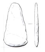
Early Bronze Age flat axehead from Postwick. (© NCC)
Sites from the Bronze Age is less numerous, although there are a small number of ring ditches or round barrows scattered across the parish that may be attributable to the period (NHER
12827, NHER
31638). A very battered tip of a Late Bronze Age spearhead was recovered just west of Postwick village (NHER
9649), as well as a copper alloy palstave (NHER
17945) very close to the concentration of flints mentioned above. Of particular interest is the fragment of a Late Bronze Age copper alloy sickle found just north of the Postwick Marshes in a loop of the River Yare.
Evidence that can be specifically linked to the Iron Age is more rare. A few Iron Age coins (NHER 25698, NHER 13603) have been recovered in two places within a kilometre southeast of the large flint concentration, and pottery sherds have also been recovered 500m to the northeast (NHER 29070), as well as further east on the opposite side of Postwick village.
By comparison, finds and monuments of the Roman period are more substantial, with over a third of all sites in the parish producing objects from this period. These are largely located in a band across the middle of the parish, either side of the railway line that traverses the parish east to west. Of particular interest are a number of Roman period pottery kilns discovered in 1995 (NHER 31108), in area that represents one of the most northerly areas of Roman activity in the Parish. Here there is evidence that pottery production had been taking place in the prehistoric period, and continued or was revived, during the Roman period.
Also of interest is a hoard of Roman coins recovered just west of Postwick village (NHER 13603), close to the concentration of prehistoric flint work. Coins from this hoard, which appears to have been scattered by agricultural activity, were first recovered in 1986, and have been recovered intermittently over the last twenty years. Roman pottery, including ceramic building materials, as well as a figurine, brooches, a bracelet and a finger ring have all been recovered in the same area, possibly indicating the presence of a Roman building.

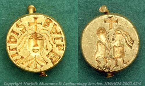
The famous Middle Saxon Bathilda seal matrix from Postwick. NWHCM 2000.42:A (© NCC)
As a result of regular metal detecting this area (NHER
13603), in the west of the parish, is one of the richest sites in Postwick, and a surprisingly rich and exciting range of metal work has been recovered from the Saxon periods. The centrepiece has to be a delightful 98% solid gold seal matrix from AD 648, belonging to Bathilda, an East Anglian who was captured by raiders and sold into slavery in the court of the Frankish king Clovis II, an area that is part of modern day France. Amazed by her beauty and grace he married her, and when he died she ruled as regent for their son, and was canonised following her death. The seal itself uses a portraiture style very similar to coins of this period, but the real surprise is on the reverse. Whilst most seal matrices have plain reverses, Bathilda’s seal is engraved with a image that would be hidden during normal use, and portrays a couple making love. Rumours abound as to what value this seal possessed for Bathilda, and how it reached the lands of her birth, but it remains a truly unique object.

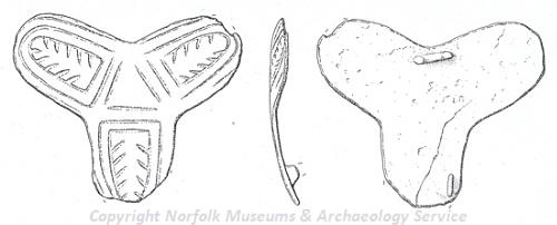
A Late Saxon copper alloy trefoil brooch from Postwick. (© NCC)
The sheer range of material from this site (NHER
13603) is significant enough to suggest occupation, at least periodically, from the Neolithic to the post medieval periods. Certainly the Domesday Book indicates that although the parish was not valued as outstandingly rich, it was of good quality and possessed both a mill and a church by 1066. Witton, a separate unit at that time, appears to have neither, and seems to have been largely given over to arable crops. saxon finds have also been made at other sites. These include an unusual trefoil brooch (NHER
31762).

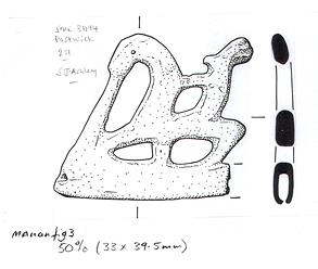
Viking horse and rider brooch from Postwick. (© NCC)
Whether the Domesday Book refers to Postwick’s current church, or to a different and now destroyed building, is unclear. Local legend mentions a now destroyed chapel of St Ethelred, which may be a possibility, placing it either in the current village or just north. The only other known ecclesiastical site is the current parish church of All Saints (NHER
9695), one of only two listed buildings in the parish. This building is in the centre of Postwick village, just west of the War Memorial. The earliest part is the chancel, dating from the 13
th century, second to which is the embattled two-stage west tower, which dates to the 14
th century. The nave also retains some windows in the Decorated and Perpendicular Styles of English Gothic architecture, placing them between 1240 and 1530, although over enthusiastic 19
th century remodelling affects the whole exterior.
The church of Witton village represents the only other Listed Building in the parish of Postwick. Named St Margaret’s Church (NHER 10264), the earliest parts remaining appear to date back from the same period of construction as All Saints’ in Postwick village, although a blocked 12th century doorway at the west end survives despite 19th century rebuilding. The most stunning feature is a large early Norman round tower, clearly built after the main church building, and given an octagonal extension in the 17th century. Although the Domesday Book does not mention any church in Witton, a church of some form seems likely to be present on this site less than a hundred and fifty years after the survey. Inside can be found a 16th century example of one of only four brasses in Britain relating to the Order of the Vowesses, widows who vowed never to remarry.
Although we would normally expect a parish of this size to be the possession of a lord of the manor during the medieval period, evidence for a manor house is unclear. The site of the present Postwick Hall (NHER 17844), sited on the north-western edge of Postwick Marsh, was named as the residence of a ‘gent’ in 1576, however most of the visible parts of the Hall date to after 1780. Other potential sites for the medieval manor house include Postwick House Rectory in the centre of the village (NHER 17846), or a site 70m to the south (NHER 17845). Indeed, the presence of nearby Orchard Acre (NHER 17847), a late medieval brick extension to the earlier flint-built Cherry Cottage (NHER 17847), in such a small village is remarkable enough to suggest that the Manor must have been sited nearby.
Medieval objects have been recovered from a large number of areas across the parish, although little metal detecting work has been undertaken in Postwick village so there are no objects from that immediate area. Some of the most exciting pieces recovered include a late medieval spoon handle with a copper alloy Virgin and Child (NHER 16269), a medieval silver wire ring brooch (NHER 20331), a gilt copper alloy chape with black niello or enamel work (NHER 24804), and a number of seal matrices in lead, copper alloy and silver (NHER 31087, NHER 25177, NHER 25170). Coins, tokens and cloth seals have all been reasonably numerous, and it is evident that Postwick was successfully engaged in medieval economic activities, which is unsurprising considering its proximity to the coast road.
Evidence from the post medieval period is almost as numerous as that from the medieval. Several sites of interest are scattered across the parish, including a brick kiln near the village of Witton (NHER 37144), which is one of the few sites from any period in that area. To the southwest, the majority of Postwick Hall (NHER 17844) dates to after 1780, having been largely constructed under the Rosebery family who acquired the estate in the early 19th century. In Kelly’s Directory of Norfolk from 1900, the Earl of Rosebery is listed as lord of the manor and owner of nearly the whole parish. The fifth Earl of Rosebery went on to become Prime Minister between 1894 and 1895, having married an heiress of the Rothschild family.
It should also be noted that possibly the most important battlefield in post medieval Norfolk is also cited in Postwick. In August 1549 Kett and his rebels met the Earl of Warwick’s army in the valley known as Dussindale, and part of this site is thought to lie on the very westerly border of Postwick (NHER 21173). Kett and his followers were protesting against the enclosure of public lands by the rich estate owners of the time, but although they succeeded initially in taking Norwich, they achieved little in the long run and the enclosures went ahead. For more information see the BBC website listed below.
As well as the remains of drainage and milling equipment, (NHER 10260, NHER 15584), there have been some beautiful post medieval finds recovered in Postwick, including a lovely 17th inscribed gold finger ring (NHER 39953) and an unusual 17th century gold mourning ring (NHER 30475). As for later sites only two structures from World War Two have been identified; a well-preserved air raid shelter at the site of Lord Rosebery’s shooting lodge north of the railway (NHER 17845), and a Type 22 pillbox on the side of the river at Riverside Barn (NHER 32540).
The south-western core of Postwick therefore represents one of the densest distributions of finds in the local area, considerably more from all periods than can be seen in the adjacent parishes. The northern and eastern corners, including the village of Witton, are far sparser, with very little evidence available to interpret. The position of this parish in the crook of the Yare, blessed by good arable land and woods and well sited for transportation by road and river, has obviously contributed to the domestic and economic activity visible from the prehistoric to the modern day.
Ruth Fillery-Travis (NLA), 15 December 2006.
Further Reading
Blake, W. J. 'Parson Russell's reply to Blomefield's queries', Norfolk Archaeology Vol 39 1946 p164-80.N.R.O. Frere Ms. Brundal.
BBC Legacies Website, ‘A Tale of Two Ketts’. Available:
http://www.bbc.co.uk/legacies/myths_legends/england/norfolk/article_1.shtml. Accessed 15 December 2006
Harrison, T., 1858. Postwick and its relatives [Written in the early 18th century and edited by James Hargrave Harrison] (Great Yarmouth, 1858)
Knott, S., 2006. ‘All Saints, Postwick’. Available:
http://www.norfolkchurches.co.uk/postwick/index.html. Accessed 15 December 2006
Stoker, David. 1990. ‘Parson Russell’s History of Postwick’, Norfolk Archaeology, Vol 51
William White’s History, Gazetteer, and Directory of Norfolk, 1845