This Parish Summary is an overview of the large amount of information held for the parish, and only selected examples of sites and finds in each period are given. It has been beyond the scope of the project to carry out detailed research into the historical background, documents, maps or other sources, but we hope that the Parish Summaries will encourage users to refer to the detailed records, and to consult the bibliographical sources referred to below. Feedback and any corrections are welcomed by email to heritage@norfolk.gov.uk
Marsham is located in central Norfolk, north of Norwich and south of Aylsham. It is very roughly rectangular in shape, with Marsham village in the centre, the hamlet of Little London in the west and a number of houses and farms dotted elsewhere. Marsham Heath is located in the west. The northern parish boundary follows the course of a stream known as ‘The Mermaid’, with others following field boundaries and roads.
The archaeology of Marsham is fairly well known and sites are recorded throughout the parish. There have been plenty of stray finds and metal detecting and fieldwalking have taken place. Many site visits have been undertaken and some historic buildings survive.
Prehistoric flint artefacts have been discovered at a number of sites. They include a Mesolithic axehead, Neolithic polished axeheads, a Neolithic laurel leaf, a Neolithic or Bronze Age rod and a Neolithic or Bronze Age knife or sickle. Bronze Age metal objects have been found at several sites and comprise an awl, a chisel and a hammer.
During the 19th century a Bronze Age round barrow was recorded on Marsham Heath. It may be one of the two barrow-like features (NHER 7490 and 7491) identified in the mid 20th century. Both of these features may be barrows. A small undated mound in Bolwick Park could be a barrow, although it is more likely that it was constructed as a landscape park feature.
Five Iron Age coins have been discovered, with four found to the northwest of the village and one to the southeast. Two Late Iron Age or Roman brooches have come from the northwest. Roman artefacts have been recovered throughout and include pottery, coins, brooches, a military apron mount and a phallic pendant. A group of findspots cluster in the southeast, relatively close to site of Brampton Roman town (NHER 1006 and 1124). The coins, pottery and other objects found in this area could suggest that the suburbs of the town may have spread westwards from Brampton parish (although they could instead indicate rubbish disposal and/or casual losses).
The Roman road (NHER 2796) from Brampton to Denver passed east to west through the south of the parish. This or a second Roman road may have been investigated before 1849 when Roman pottery was found amongst a group of earthworks. Unfortunately, the exact location of this work is not known. The discovery of Roman pottery, brick, tegulae, coins and possible kiln furniture to the south of the Brampton to Denver road indicates the site of a Roman settlement (NHER 24414). Undated enclosures visible on aerial photographs (NHER 45327) may have been an integral part of this.
A number of sites throughout have produced Saxon or possible Saxon artefacts. The objects include a Roman or Early Saxon belt stiffener, Early and Late Saxon brooches, Late Saxon fittings and a coin of Edward the Confessor. Some of the Late Saxon objects have been found near All Saints’ Church and this suggests that there may have been a church on or close to its site since at least the Late Saxon period.
Marsham is called ‘Marsam’ in the Domesday Book of 1086. This Old English name means ‘homestead or village by the marsh’. In 1086 King William I, the Bishop of Thetford, Ralph of Beaufour and Walter Giffard held land in the parish. Freemen, villagers, smallholders, ploughs, meadow, woodland, cattle, pigs, goats and beehives were recorded, as were links with manors in Cawston, Brampton and Stratton Strawless.
All Saints’ Church (NHER 7524), a medieval and later building, is located in the south of the village. The south porch has a 13th century door and most of the chancel dates to the 19th century restoration. Inside there is a 15th century hammerbeam roof with later tie beams and binders, the remains of a 15th century screen decorated with sixteen painted saints and a font that dates to about 1460. There may have been a medieval cross (NHER 11391) to the north of the church. A large piece of masonry, probably part of a cross, was observed in 1975 during road construction work. During the medieval period there may have been a medieval hamlet called ‘Bolwick’ in the north of the parish. This could have been close to Bolwick Hall and possibly where a small undated mound stands.
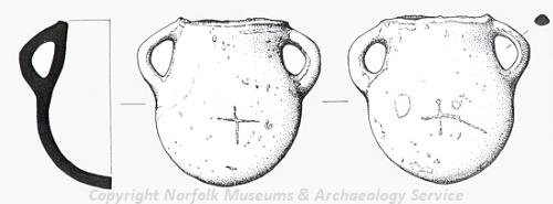
A possible vessel from a medieval christmatory found in Marsham. (© NCC)
Medieval and post medieval artefacts have been discovered throughout and include coins, jettons, metal objects and pottery. Most of the coins are English, although a few come are from further afield; they include Scottish, Portuguese, Spanish and Venetian examples. Amongst the metalwork is a medieval vessel that would have held religious oil or unguent (NHER
39717), a 13th century gold finger ring (NHER
45326) and a medieval seal bearing the arms of England and France.
Surviving post medieval buildings include the Old Registry, The Grange, Marsham Hall, Grove Farmhouse, The Old Rectory and the Village Hall (a former improvement institute). Marsham Hall (NHER 25917) is located in the south, was built during the 18th century and is surrounded by a small landscape park. Although Bolwick Hall is in Aylsham parish, its landscape park (NHER 44782) extends into the north of the parish. The park includes two possible landscape mounds and the site of Bolwick Mill (NHER 23025). The mill was closed in 1812 when a second mill was opened to the northeast.
Bryant’s map of 1826 shows a post mill in the southeast. A ring ditch in the south centre could the remains of a second post medieval post mill. In 1855 the Buxton Reformatory (NHER 41862) was founded in the east. It was designed as an open prison and as an alternative to standard prisons, with the aim of training offenders under the age of 20. It was later known as Red House Farm School when the focus was on agricultural training. It was demolished in 2002.
An undated mound with steep sides and a narrow top (NHER 32346) survives on Marsham Heath. It could be an archery, musketry or artillery butts and may date to World War One or earlier. During World War One there was a military airfield (NHER 13619) to the southwest of the village. In the centre of the village is a modern K6 type telephone kiosk.
David Robertson (NLA), 21 June 2006.
Further Reading
Ashwin, T. & Davison, A., 2005. An Historical Atlas of Norfolk (Chichester, Phillimore)
Barringer, C., 1989. Faden’s Map of Norfolk (Dereham, Larks Press)
Barringer, C., 1998. Bryant’s Map of Norfolk in 1826 (Dereham, Larks Press)
Brown, P. (ed.), 1984. Domesday Book: Norfolk (Chichester, Phillimore)
Knott, S., 2005. 'All Saints, Marsham'. Available:
http://www.norfolkchurches.co.uk/marsham/marsham.htm. Accessed: 22 June 2006.
Mills, A.D., 1998. Dictionary of English Place-Names (Oxford, Oxford University Press)
Neville, J. 2003. 'Bolwick Mill'. Available:
http://www.norfolkmills.co.uk/Watermills/bolwick-shreeve-family.html. Accessed 22 June 2006.
Neville, J., 2004. 'Marsham postmill'. Available:
http://www.norfolkmills.co.uk/Windmills/marsham-postmill.html. Accessed: 22 June 2006.
Rye, J., 1991. A Popular Guide to Norfolk Place-names (Dereham, Larks Press)