This Parish Summary is an overview of the large amount of information held for the parish, and only selected examples of sites and finds in each period are given. It has been beyond the scope of the project to carry out detailed research into the historical background, documents, maps or other sources, but we hope that the Parish Summaries will encourage users to refer to the detailed records, and to consult the bibliographical sources referred to below. Feedback and any corrections are welcomed by email to heritage@norfolk.gov.uk
The long narrow parish of Frettenham is situated in the eastern part of Norfolk, to the north of Norwich. Its name comes from the Old English for ‘Fretta’s homestead’, fretta being a nickname meaning ‘wanton’. The parish has a long history, and was certainly well established by the time of the Norman Conquest, its population, land ownership and productive resources being detailed in the Domesday Book of 1086.
The earliest evidence of human activity comes in the form of flint tools, some of which are only classified as prehistoric (NHER 16547), but the oldest dateable example of which is a Palaeolithic axe (NHER 18828) found to the west of Chisel Hill. There are so far no Mesolithic flint finds, but Neolithic activity is evidenced by the discovery of part of a Neolithic polished axehead (NHER 7987).
There was once a site in the west of the parish where several Bronze Age round barrows were observed in the 19th century (NHER 7990), but unfortunately these have since been destroyed by gravel extraction. No further barrows or their remains have since been noted, but several Bronze Age copper alloy axeheads have been found on Frettenham Common (NHER 7991, 7992 and 7993). Pottery fragments (NHER 7988) and a stone axehammer (NHER 7645) have also been located. Iron Age finds are so far scarce, and the only certainly dateable object recovered has been a harness fitting with some surviving enamelling (NHER 24608) found in the southern part of the parish. Some pottery fragments (NHER 7987) may be Iron Age, but may equally well be Early Saxon (the two are often hard to tell apart). Another harness fitting (NHER 23404), also located in the south of the parish, may also be Iron Age, but could be Roman (the same applies).
Finds from the period of the Roman occupation are more numerous. Quite a number of coins have been turned up (for example NHER 22608, 28765 and 28975), together with brooches (NHER 28765, 28975 and 35266), pottery fragments (NHER 7995), part of a bracelet (NHER 28975) and a hairpin (NHER 35266). Also, at the very southern end of the parish, a low earthwork running north to south for about a hundred metres may be a section of Roman road (NHER 22951). Following the departure of the Romans, evidence of activity drops away somewhat, with finds to date being a couple of Saxon strap ends (NHER 35266 and 39905) and a buckle pin (NHER 28975).

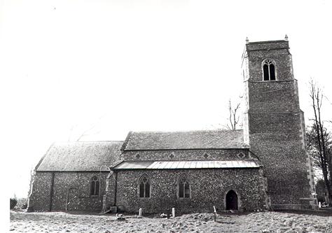
St Swithin's Church, Frettenham. The building dates to the 14th century, with 15th and 16th century alterations. (© NCC.)
The medieval period following the Norman Conquest has left Frettenham with its oldest surviving building, St Swithin’s Church (NHER
8024). This church, situated in an isolated position in the centre of the parish, is mainly 14th century, with 15th and 16th century alterations. It consists of a west tower with traceried sound holes, an aisled nave, south porch and a chancel that was completely rebuilt in 1969. Inside is a 13th century font (though its base and stem are replacements). Restoration work in 1986 uncovered a complete aisle floor of tiles dating to about 1400, and medieval wall paintings. There are no other medieval buildings, but a number of objects from the period have been recovered. These include coins (NHER
28765,
28975 and
35266), pottery fragments (NHER
23404), and a seal matrix, cup, trade token and part of a key (NHER
28765).
Post medieval objects recovered include coins (NHER 28975, 39907 and 39909), a coin weight (NHER 37527) and a ring (NHER 35266). As to buildings of this period, Church Farm (NHER 29964), southwest of St Swithin’s Church, is a complex of farm buildings, consisting of two 18th century brick barns and a brick and flint stable and harness room that may pre date them. There is also a tarred brick tower mill in the village itself (NHER 8021), built in about 1880. The tower remains, and although disused, is remarkable in that it retains almost all of its interior machinery.
Records indicate that there was a World War One landing ground (NHER 13617), but its exact location is not known. Unlike later airfields, these were basically just grass strips, and leave little or no trace of their existence.
Piet Aldridge (NLA), 23 January 2006.
Further Reading
Brown, P. (ed.), 1984. The Domesday Book, 33 Norfolk (Chichester, Phillimore & Co.)
Rye, J., 1991. A Popular Guide to Norfolk Place Names (Dereham, The Larks Press)