This Parish Summary is an overview of the large amount of information held for the parish, and only selected examples of sites and finds in each period are given. It has been beyond the scope of the project to carry out detailed research into the historical background, documents, maps or other sources, but we hope that the Parish Summaries will encourage users to refer to the detailed records, and to consult the bibliographical sources referred to below. Feedback and any corrections are welcomed by email to heritage@norfolk.gov.uk
The parish of Bradwell is west of Great Yarmouth in the very south of the county. The origins of its name are not certain, but may mean ‘broad stream’. There are currently 125 entries on the archaeological record for the parish, but it should be kept in mind that the area has been extensively explored by metal detector and by fieldwalking, and therefore the majority of the records are metal and flint spot finds. Examples of these will be given, but for a fully detailed examination of the range of finds, the HER itself should be consulted.
The earliest evidence of human activity in the parish comes in the form of Mesolithic flint tools, including a blade (NHER 10399) and axes (NHER 11787 and 12780).
Finds from the Neolithic are also characterised by flint tools such as scrapers (NHER 10399 and 29166), chipped or polished axes (NHER 10571, 14315 and 11787). Also, some sites have yielded a range of Neolithic flints, together with later artefacts, and may have been settlement sites (NHER 12780). Others indicate evidence that they were an area where flint tools were made (NHER 11551).
The gradual change from the Neolithic to the Bronze Age is illustrated by the fact that flint tools were used well into the latter. In this parish for example, Bronze Age flints were found at NHER 12780. Technology changes, however, led to the increasing use of copper alloy as a tool material, and three axeheads made of this have been found at NHER 13655, 28070 and 28071. The Bronze Age has also left the possible footprints of its burial sites. At least a proportion of the population in this period were buried in circular mounds or round barrows, heaps of earth with one or more surrounding ditches. Over the centuries, these barrows were flattened by agriculture, but the remains of their ditches can sometimes be seen from the air. This has led to the tentative identification of several ‘ring ditches’ in the parish (NHER 11787, 12777 and 12779).
Iron Age finds are limited to some fragments of pottery and a brooch that may date to the period. A small hoard of coins has also been found.
Considering the proximity of the nearby Roman fort at Burgh Castle, Roman finds in Bradwell are relatively sparse at present. Coins have been found at several locations (e.g. NHER 10399, 10542, 11551, 12310, 16470 and 17854), and other Roman discoveries include a finger ring (NHER 22353) and a brooch (NHER 18642). There is no evidence of structures or field systems. Having said that, work is currently in progress charting a mass of cropmarks in the parish that are visible from aerial photographs, and it seems likely that our understanding of the history of the area will soon be greatly enhanced.

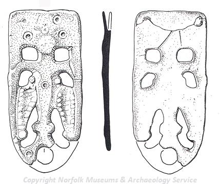
A Late Saxon strap end from Bradwell. (©NCC)
Following the departure of the Romans, and before the Norman Conquest, finds in the parish from the Saxon period have been almost exclusively located by metal detecting. These include coins (NHER
10399 and
18661), brooches (NHER
11787,
21796 and
25295), a book mount (NHER
18004) and a decorated strap end (NHER
18861).
The medieval period gives the parish its oldest surviving building in the form of St Nicholas’ church, which has a 12th century round tower. The rest of the church is mainly 14th century with later alterations. There are no other surviving buildings, but again, metal detecting enthusiasts have added to the archaeological record with finds such as coins (NHER 15796, 17263 and 18861), a buckle (NHER 15796), a brooch (NHER 15796), a bell (NHER 17854) and a lead seal matrix (NHER 17264).
Two buildings from the post medieval period survived in 2005, both of them barns. The barn at Bradwell Hall (NHER 34078) was originally a stable and hayloft, and has a date plaque of 1731. Church Farm barn (NHER 41229) is an 18th century threshing barn, but was in poor condition when seen in 2005, and may since have been demolished. Other structures that appear on old maps have since disappeared. For example, three post medieval wind pumps to drain marshy ground (NHER 31135, 34379 and 34995) have vanished, as has a windmill (NHER 10589). Also Bradwell House (NHER 41228), a house of about 1812, was demolished in 1983, and has now been built over.
Recently, several wooden revetments (retaining walls to stop sea incursion) have been discovered (e.g. NHER 41634 and 41635), and it is likely that these date to the 19th century.
The nearby port of Great Yarmouth was a bombing target in World War Two, and aerial photographs of the time show that Bradwell suffered its fair share of hits during German raids. Bomb craters are visible at several locations on these photographs, although of course most were subsequently filled in. Other World War Two features were a pillbox (NHER 32665), now demolished, and a radar and searchlight station (NHER 11787) that was dismantled at the end of the War.
The most recent entry on the record is from 1953, and is a meshed trackway that was laid after the floods of that year to allow sandbags to be moved from ships to block breaches in the sea defences.
Piet Aldridge (NLA), 23 November 2005.
Further Reading
Norfolk Federation of Women’s Institutes, 1990. The Norfolk Village Book (Newbury, Countryside Books)