This Parish Summary is an overview of the large amount of information held for the parish, and only selected examples of sites and finds in each period are given. It has been beyond the scope of the project to carry out detailed research into the historical background, documents, maps or other sources, but we hope that the Parish Summaries will encourage users to refer to the detailed records, and to consult the bibliographical sources referred to below. Feedback and any corrections are welcomed by email to heritage@norfolk.gov.uk
Winterton On Sea is situated on the north Norfolk coast, and is part of the Great Yarmouth local government district. This parish contains the village of Winterton on Sea, as well as the settlements of Winterton Holmes and Winterton Ness. The large stretches of dunes that cover the coastline here form the Winterton Dunes nature reserve. The name ‘Winterton’ is derived from the Old English for winter enclosure.
A small number of objects from the earliest periods of human occupation have been recovered, but these are limited to two flint flakes (NHER 17099, NHER 44777), a Neolithic polished flint axehead (NHER 17131), and a Bronze Age rapier blade. There have also been a small number of features noted on aerial photographs of the parish, some of which may date to the prehistoric period, such as an undated field system to the south of the village (NHER 43400), and a possible Bronze Age round barrow near Mill Farm (NHER 43398).
Evidence from the Roman period is limited, but there have been a small number of finds which suggest the presence of a Roman salt extraction plant close to the sea (NHER 43800). A human skeleton, in association with Roman period pottery sherds and animal bones was also recovered nearby (NHER 41181), and may relate to the same site, as may pottery and tile fragments from ditches near the beach (NHER 40106).
Only two finds of Saxon period objects have been recovered, and both of these are pottery sherds (NHER 8407, NHER 34397). However, Winterton is noted in several places in the Domesday Book, and although it does not appear to have populous or wealthy, there is mention of a salt works in the parish.

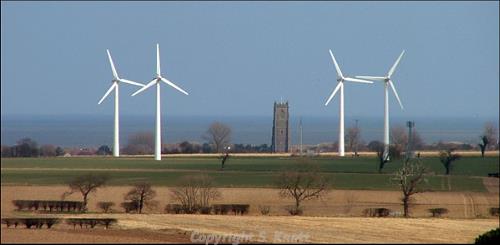
Holy Trinity and All Saints' Church, Winterton-on-Sea. Photograph from www.norfolkchurches.co.uk (© S. Knott.)
The earliest surviving building in the parish is the Holy Trinity and All Saints’ Church (NHER
8582), which is situated close the coast. Although it has an impressive seven-stage tower, which rises over 40 metres, the church itself is small and almost disappears behind it. This is likely due to the fact that the tower was built as a landmark to aid ships at sea, the proximity of which is visible in the corroded stonework and the memorials inside.

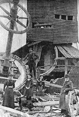
A mill near Downing Farm, Winterton. Photograph from www.norfolkmills.co.uk
Other possible medieval sites are limited to a small number of medieval and possible medieval earthworks such as a moat (NHER
8575), drains (NHER
42382), and possible pond or broad (NHER
42360). Also of interest is the site of a medieval or early post medieval mill near Downing Farm (NHER
12188), the earthworks of which are visible on aerial photographs, and which may be one of a number built on this south-facing spur of land. Also dating to the medieval or post medieval period is the site of a wreck (NHER
31794) revealed at high tide in 1991, which appears to have been reused as a groyne or revetment.
One of the most notable buildings of the parish is the Lighthouse (NHER 8576), which was built in 1840 on the site of earlier lighthouses. Although it went out of use in 1921 and became a holiday home, the building was reused during World War Two as an observation post for the Winterton Emergency Coastal Battery, and a brick and concrete stage added above the gallery. It has now been split into two dwellings, one in the tower and the other in the adjoining building.
Other features of interest include a 19th century duck decoy (NHER 30618), the remains of which can be seen as earthworks and cropmarks on aerial photographs. It was built in 1807 and abandoned in 1875, although the central pond survives. Aerial photographs also indicated other post medieval features such as enclosures (NHER 42361), field systems (NHER 43399), and drains (NHER 42381).
Objects from the medieval and post medieval periods are not numerous, however a medieval casket key (NHER 32038, 15th or 16th century French coin (NHER 30966) and a coin of Elizabeth I (NHER 18348) have been recovered, along with a medieval lead belt mount (NHER 34400) shaped like a devil’s face.
Due to its coastal position Sea Palling was the subject of aerial photography during World War Two, and in recent years the Norfolk National Mapping Project has been analysing and identifying the features depicted on these images. As a result a large number of features, particularly those that were built during the World Wars and later demolished, have been added to the NHER. As a result, there are over forty-five archaeological sites from World War One and Two, over half of all those recorded here.
A number of rare survivals from World War One include a probable rifle range on Winterton Dunes (NHER 42440), and practice trenches just 280m to the southeast (NHER 42447), and elements of both survive as earthworks today.
However, it is during World War Two that this parish saw the greatest intensity of occupation and building. It is recorded that a network of defences (NHER 42130, NHER 42183, NHER 42368, NHER 42444) were located along the coastline here, with barbed wire and beach scaffolding covering the whole stretch by 1944 (NHER 27278, NHER 42132), a minefield on the dunes (NHER 42453), an Emergency Coastal Searchlight and Battery (NHER 35863, NHER 42454), and a military camp (NHER 42500).
A radar and ‘Oboe’ navigation site (NHER 35862)was also built at Blood Hill as part of these defences. This radar station was initially a Coast Defence/Chain Home Low station, used to detect enemy shipping, before being converted to Chain Home Extra Low to detect aircraft and also given the Oboe equipment necessary for it to act as a navigational aid for bombers attacking the continent.
It should also be noted that a large cluster of anti-invasion defences (NHER 42452, NHER 25471) were erected around Winterton Gap which was thought to be extremely vulnerable to attack by an invading force. These included tank traps (NHER 18355), which have suffered erosion and now lie on the beach (NHER 41604, NHER 41812).
Other sites include a World War Two Naval bombing decoy for Great Yarmouth which was situated at Winterton Ness (NHER 13606, NHER 29752). It comprised a Starfish site, which used structures containing burning material to imitate the fires started by a bombing raid, and lights to imitate an ineffective or partial blackout.
Although almost all the World War Two sites mentioned above have since been dismantled or destroyed by coastal erosion, some survive today. These include fragments of a number of World War Two pillboxes (NHER 31791, NHER 31792, NHER 41599), as well as over seventy tank trap blocks, (NHER 32648, NHER 41604), the remains of a Coastal Artillery searchlight (NHER 41600, NHER 41603), and a number of bomb craters (NHER 42363, NHER 42362).
From more recent history a Cold War Royal Observer Corps post (NHER 35435) has been observed in aerial photography and on the ground. This structure appears to have been constructed partially underground in the sand dunes, and as a consequence the shaft is filled with sand and the structure appears to be badly damaged. There is evidence for an Orlit A post here, as well as what may have been an earlier World War Two observation post.
Ruth Fillery-Travis (NLA), 10 April 2007.
Further Reading
Knott, S., August 2006. ‘All Saints, Winterton’. Available:
http://www.norfolkchurches.co.uk/winterton/winterton.htm. Accessed: 10 April 2007
Morris, J. (General Editor), 1984. Domesday Book, 33 Norfolk, Part I and Part II (Chichester, Phillimore & Co)
Rye, J., 1991. A Popular Guide to Norfolk Place Names (Dereham, The Larks Press)