This Parish Summary is an overview of the large amount of information held for the parish, and only selected examples of sites and finds in each period are given. It has been beyond the scope of the project to carry out detailed research into the historical background, documents, maps or other sources, but we hope that the Parish Summaries will encourage users to refer to the detailed records, and to consult the bibliographical sources referred to below. Feedback and any corrections are welcomed by email to heritage@norfolk.gov.uk
The name ‘Pulham’ is derived from Old English and refers to a ‘homestead by the pools or water meadow’. Although it has been known as ‘Pulham Market’ since 1947, the parish was originally referred to as ‘Pulham St Mary Magdalen’, to differentiate it from its close neighbour to the southeast, Pulham St Mary. The appelation ‘Market’ refers to a weekly market which took place in the 12th to 17th centuries for the sale of the hats and coverlets which were produced locally.

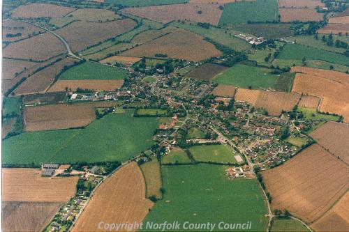
An aerial photograph of Pulham Market. (© NCC)
Pulham Market is an almost idealised picture of a Norfolk country village, with a large number of listed houses dating from the 16
th century grouped around the village green. Two old village pubs also look out onto the green, overlooked by the impressive Church of St Mary Magdalen, evidence of Pulham Market’s former glory as a market town.
The parish is bordered to the west by the A140, a road that runs along the route of a Roman Road refered to as the Pye Road. The parish is roughly oblong, the village of Pulham Market sitting in the middle lower half of the parish. To the north are the Cole’s Common and Colegate End areas, and to the south lies The Hall (NHER 10972) and its associated lands.
Evidence for exploitation during the prehistoric period is limited to a small number of finds, the majority have been recovered from the north of the parish, between the Cole’s Common and Bush Green regions. The majority of these are flint axeheads (NHER 10948, NHER 10950, NHER 21026, NHER 22466), although a flint dagger and a shaft hole adze have also been recovered (NHER 19005).
Although there are no monuments dating to any period before the medieval, there have been a small number of Bronze Age objects, including a stone axe hammer (NHER 10952), an arrowhead (NHER 19005). Iron Age finds are usually very infrequent, but there have been two Iron Age bow brooches recovered (NHER 10768, NHER 34972), as well as a silver Iceni boar-horse type coin (NHER 31506), all of which have been near to the eastern border of the parish, in a line running roughly north to south.
Interestingly, a large number of finds from the Roman period were also recovered from the same area. These include a number of brooches (NHER 32109, NHER 31896), coins (NHER 31914, NHER 31506), personal and clothing adornments (NHER 34972), and even a small number of pottery sherds (NHER 10768). A smaller group just south of the village of Pulham Market included similar objects, as well as sherds of fine Samian ware. Just 100m away from that group, the fragments of a Dressel 20 amphora (NHER 16009) and a copper alloy cauldron or bowl (NHER 22620) were also recovered. The relatively high quality and domestic nature of these objects, and their close proximity to each other may indicate the presence of a Roman settlement. Evidence for Saxon settlement in the area is sparser, with just a few objects recovered from an area just east of the village. These include Late Saxon coins (NHER 31506), an Early Saxon girdle hanger and Middle Saxon pin (NHER 34972) and an Early Saxon glass bead (NHER 39384). By comparison, the medieval period has given us the earliest confirmed monuments and buildings in Pulham Market, present in both the village and the surrounding countryside.
Of some interest is Foxholes Farm, on Cole’s Common to the north of the village (NHER 10774). Although the remaining building dates to the 1600s and later, it is based on an earlier building and surrounded by a moat also believed to date to the medieval period. Other sites retaining a moat of probable medieval date include Hill Farm (NHER 10780) on the very eastern border of the parish, Manor Farm (NHER 13945) to the north of Cole’s Common, as well as two sites to the east of the village (NHER 18420 and NHER 18421).
Later medieval buildings are also surprisingly common, including Town Farm on Cole’s Common (NHER 39795), and remnants of medieval buildings can be found as part of both Andrew’s House in the village (NHER 40840), and Low Farm, an ornate late medieval passage house (NHER 10962). This quantity of moated sites and medieval buildings is not common and indicates the success of Pulham Market during the medieval period. This prosperity would have been an attractive feature, and may have contributed to the dersertion of Semer medieval village (NHER 11919), which is believe to have lain to the south in this, or the nearby Dickleburgh and Rushall parish.
Although the parish of Pulham Market has not been subject to intensive metal detector activity, there have been a number of medieval objects recovered. These include a good number of everyday objects such as coins (NHER 10768), pottery sherds (NHER 22465) and inexpensive personal ornaments like buckles and buttons (NHER 34972). Of particular interest is a gold signet ring with a bird device (NHER 10769), a whole 15th century unglaze stoneware jug (NHER 10954), and a silver ring brooch (NHER 31507).
A surprising number, close to a hundred, of post medieval buildings have also survived, to the extent that they represent almost three quarters of sites in the parish. With such a large number of buildings to choose from, making a selection is difficult, however of particular interest is St Mary Magalene’s Church (NHER 10953) which sits on the green just behind the Crown Inn (NHER 12675). The church is not mentioned in the Domesday Book, and the earliest remaining part is the tower, which dates to the 15th century. Although the church was subject to an expensive Victorian restoration, the majority of the structure remained untouched and the money was spent on such things as stained glass and a repainting of the wall paintings over the chancel arch and in the last bay of the nave roof, which were originally medieval.

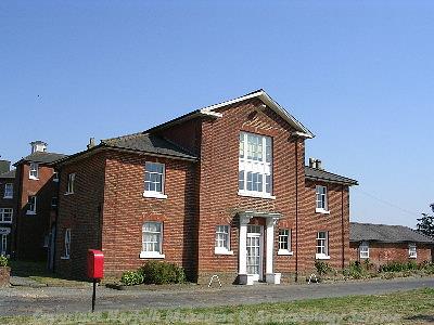
The severe facade of the early 19th century workhouse at Pulham Market. (© NCC)
Another building of potential interest is the former Depwade Union Workhouse, which during the 19
th century held up to three hundred inhabitants (NHER
10965), and has now been converted to flats. Also of 19
th century date, or possibly earlier, is a smock mill (NHER
15785) that stood on the southern edge of the village Recreation Ground, and is now demolished. Of earlier date, the Hall (NHER
10972) is located to the southwest of the village. The Hall is basically Elizabethan in date with 18
th century rebuilding, and was anciently in the possession of the younger branch of the famous Percy family, Earls of Northumberland.
In keeping with the successful image of Pulham Market, there are also two village inns, the origins of which may lie in the late medieval period. The Crown Inn (NHER 12675) sits on the south side of the village green, and appears to have been pieced together from two separate timber framed buildings around 1600. The Falcon Inn (NHER 45907) is more recent, a brick building of the 18th century situated on the opposite side of the village green to the Crown. To either side of the Inns, surrounding the village green and scattered along many of the streets in all directions, lie the numerous other buildings, which despite their number are in most cases more picturesque than architecturally interesting, being largely derived from the 17th and 18th centuries.
A small number of post medieval objects have also been recovered, including coins (NHER 41866), tokens (NHER 34972) and pottery sherds (NHER 10774), as well as more interesting finds such as the remains of a stained glass window from Foxholes Farm (NHER 10774), and a wall painting in Manor Farm, a late medieval or early post medieval period house which is considered to be an excellent example of a small yeoman’s house (NHER 13945).

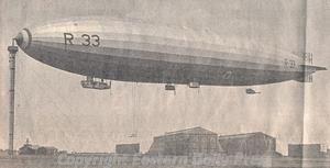
A 'Pulham Pig', an airship, at her mooring mast at Pulham airfield. (© Eastern Daily Press.)
Pulham Market parish also contains an exciting site associated with the construction of, and experimentation with, airships. The shape of these massive hardshelled balloons and their early yellow-buff colour led to them being referred to as ‘pigs’, and the site, initially owned by the Admiralty, gained the nickname ‘Pulham Piggery’ (NHER
12413). After World War One captured Zeplins were stored here whilst being examined by engineers, however the failures and disasters of airship operation in the 1910s and 1920s led to the eventual clossure of the Piggery as an airship base, and the dismantling of the huge hangars required to house the ships.
The site remained in use for storage during World War Two, despite heavy bombing, and retained an internal narrow gauge railway which survived until 1958, as well as a national railway connection until 1960. During World War Two there was also at least one searchlight battery (NHER 34059) and one pillbox (NHER 32716) present in the parish.
Ruth Fillery-Travis (NLA), 8 January 2006.
Further Reading
GENUKI. Information on Pulham Market. Available:
http://www.origins.org.uk/genuki/NFK/places/p/pulham_market/. Accessed: 8 January 2006
Hunt's Directory of East Norfolk with Part of Suffolk, 1850.
Morris, J. (General Editor), 1984. Domesday Book, 33 Norfolk, Part I and Part II (Chichester, Phillimore & Co)
Mortlock D. P. & Roberts, C. V., 1981. The Popular Guide to Norfolk Churches No. 2, Norwich, Central and South Norfolk (Acorn Editions)
Neville, J., 2004. ‘Pulham Market smock mill’. Available:
http://www.norfolkmills.co.uk/Windmills/pulham-market-smockmill.html. Accessed: 8 January 2006
Pevsner, N., 1997. The buildings of England: Norfolk 2: Northwest and South (London, Penguin Books)
Rye, J., 1991. A Popular Guide to Norfolk Place Names (Dereham, The Larks Press)
Southall, H., 2006. ‘A Vision of Britain Through Time:Pulham St Mary Magdalene’. Available: http://www.visionofbritain.org.uk/place/place_page.jsp?p_id=3111&st=Pulham%20St%20Mary%20Magdalene. Accessed: 8 January 2006
Southall, H., 2006. ‘A Vision of Britain Through Time:Pulham Market’. Available: http://www.visionofbritain.org.uk/unit_page.jsp?u_id=10049830. Accessed: 8 January 2006