This Parish Summary is an overview of the large amount of information held for the parish, and only selected examples of sites and finds in each period are given. It has been beyond the scope of the project to carry out detailed research into the historical background, documents, maps or other sources, but we hope that the Parish Summaries will encourage users to refer to the detailed records, and to consult the bibliographical sources referred to below. Feedback and any corrections are welcomed by email to heritage@norfolk.gov.uk
The parish of Hindolveston is situated in mid North Norfolk, directly south of Melton Constable. Its name comes from the Old English for ‘Hildwulf’s farm or settlement’. The parish has a fairly long history, and was certainly well established by the time of the Norman Conquest, its population, land ownership and productive resources being recorded in the Domesday Book of 1086.
Unusually, there are very few indications of early human activity on the archaeological record, and most of the parish’s entries relate to post medieval buildings of interest. There are no Palaeolithic or Mesolithic finds, and a flint dagger (NHER 3087) may be Neolithic, but could equally be Bronze Age. The only Bronze Age find is a polished flint knife (NHER 3086). There is currently no evidence of activity from either the Iron Age or the Roman periods, and the only Saxon object is a decorated strap end with traces of gilding (NHER 22214).

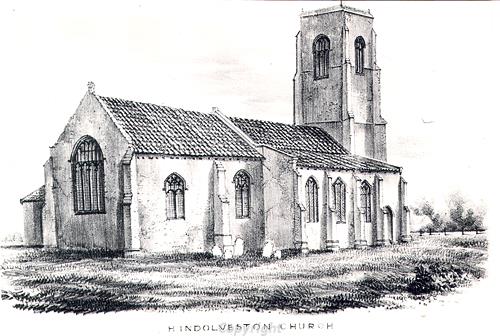
St George's Church, Hindolveston. The church is now a ruin after the west tower collapsed and demolished the nave in 1892.
The medieval period has left the parish with its earliest surviving building, or rather the ruins of it. St George’s Church (NHER
3093) was a stately building until the west tower collapsed onto the nave in 1892. All that remains today is the west wall of the tower, the vestry and a few low walls, although much of the church was used to build the new St George’s (see below), and the churchyard is still in use. The only other building to have medieval origins is Blue Tile Farm (NHER
31394), the eastern part of which dates to about 1500.
The post medieval buildings in the parish are too numerous to mention in full for the purposes of this summary. In particular, The Street has a range of interesting houses and shops dating from the 16th century (e.g. NHER 43808) to the 19th century (e.g. NHER 43813). Those whose houses are not mentioned should consult the detailed record, and no offence is intended by their omission. Other buildings to mention include Moore’s Farm (NHER 19779), which is 16th to 17th century, with its nearby 17th or 18th century barn, Church Farmhouse (NHER 3095), an H shaped farmhouse, formerly a manor house, that dates to about 1650, though with later alterations and additions, and Hope House (NHER 3097). This last building, which has a date of about 1714, has a fine Queen Ann style front and two single storey mid 18th century extensions to the east and west. Nethergate Farm (NHER 43816), its barn (NHER 43817) and Tipples Farmhouse (NHER 43819) are all 18th century, as is Whitehouse Farmhouse (NHER 43820), which has an attached threshing barn, a rare thing in Norfolk.
Buildings from the 19th century include a brick tower mill (NHER 3096), built in 1844, last used in 1908 and later converted to a house, and the Methodist Church (NHER 43815), which is early 19th century with interlaced iron railings at the front.
The new St George’s Church (NHER 3094) was built in 1932 to replace the ruined medieval one (see above). It is cruciform in shape and successfully incorporates much material from the old church, particularly the limestone detailing and arches. The 15th century font has also been reused, as have several monuments and brasses.
The most historically recent entry on the record is a World War Two aircraft crash site (NHER 24563). A Wellington bomber crashed in 1943, killing the crew. One of its propellers was recovered in 1985.
The patchiness of the early archaeological record for the parish does not necessarily mean that there was no human activity at those times, and may merely reflect a lack of detailed investigation. For example, there has been less metal detecting than in some other parishes.
Piet Aldridge, 22 May 2006.
Further Reading
Brown, P. (ed.), 1984. Domesday Book, 33 Norfolk (Chichester, Phillimore & Co)
Rye, J. 1991. A Popular Guide to Norfolk Place Names (Dereham, The Larks Press)