This Parish Summary is an overview of the large amount of information held for the parish, and only selected examples of sites and finds in each period are given. It has been beyond the scope of the project to carry out detailed research into the historical background, documents, maps or other sources, but we hope that the Parish Summaries will encourage users to refer to the detailed records, and to consult the bibliographical sources referred to below. Feedback and any corrections are welcomed by email to heritage@norfolk.gov.uk
Kimberley is a small parish close to the town of Wymondham. The parishes of Kimberley and Carlton Forehoe have been united, and the small village of Carleton Forehoe stands next to the landscape park that surrounds Kimberley Hall. Kimberley is derived from the Old English meaning ‘woodland clearing of a woman named Cyneburg’. Carleton is a common place-name and comes from a mixture of Old English and Old Scandinavian meaning ‘farmstead or estate of the freemen or peasants’. The suffix Forehoe, which came into use during the medieval period, comes from the group of Bronze Age barrows in the parish, known as Forehoe Hills.
There is some evidence of early activity in the parish, and prehistoric flint flakes (NHER 17033) and scrapers (NHER 28145, 38085), a Mesolithic axe (NHER 9251) and Neolithic flints (NHER 8890, 23615) have been found. Forehoe Hills (NHER 8873), from which Carleton Forehoe takes its name, are four Bronze Age barrows that were used as a meeting-place or moot by the hundred court in the medieval period. The only Bronze Age find recovered so far is a copper alloy dirk or halberd (NHER 8891).
Although no Roman settlement sites have been identified in the parish, a number of Roman artefacts have been collected during fieldwalking and metal detecting. They include coins (NHER 8914, 28139, 28369), fragments of pottery (NHER 17030, 29608, 32325), tiles (NHER 8914) and a harp-shaped brooch (NHER 8892). In 1854 an urn containing Roman coins was discovered (NHER 12355).
Early Saxon brooches (NHER 12723, 17031, 28139) and fragments of Early Middle and Late Saxon pottery (NHER 17033, 17031, 28146) have been found.
St Mary’s Church (NHER 8888) in Carleton Forehoe dates back to the 15th century, and has an early 18th century west tower. The medieval village of Carleton Forehoe was larger that the modern settlement. The earthworks of part of the shrunken village, including several tofts and house platforms, have been surveyed on Low Road (NHER 29608).

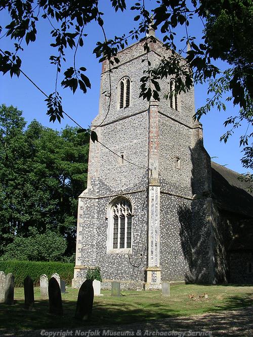
The 15th century west tower of St Peter's Church in Kimberley. (© NCC)
To the south of Carleton Forehoe is Gelham’s Wood, which is the site of a moated medieval manor house (NHER
8879). The manor was held by St Benet’s Abbey at the time of the Conquest, and the holding is recorded in the Domesday Book with five villagers, two smallholders, a plough and three acres of meadow. The earthworks of the medieval manor held by the Gelham family survive on the site. A large moated outer enclosure surrounds a smaller moat, and an earthwork depression with the outer enclosure is probably a medieval fishpond. The manor was held by the Gelhams until the late 15th century, and it was absorbed into the estates of the Wodehouses in the 16th century.
St Peter’s Church (NHER 8917) in Kimberley dates back to the 12th century, and contains many memorials to the Wodehouse family. During the medieval period a chapel dedicated to St Mary stood in the churchyard. By the early 19th century the chapel was in ruins and no upstanding remains are visible today. Several earthworks and cropmarks have been recorded in the area around Station Road. They include the earthworks of medieval tofts and a possible field boundary (NHER 12723) and a cropmark of a medieval hollow way (NHER 14401). A double-ditched enclosure and other features (NHER 8893) are visible as cropmarks on aerial photographs. Although the cropmarks cannot be closely dated, they have been interpreted as possible medieval house platforms or drainage ditches. The cropmarks of other possible drainage ditches (NHER 8894) have been recorded near Station Farm. Fragments of medieval and post medieval pottery (NHER 8914, 13497, 13498, 13744, 21007), as well as metal finds including buckles and part of a medieval horse harness (NHER 28405) have been found during metal detecting and fieldwalking.

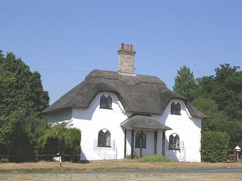
An early 19th century lodge in the style of a cottage ornee. (© NCC)
In 1086 the manor of Kimberley was held by the King, and it had passed to the Wodehouses through marriage by the end of the 15th century. The earliest manor house was a moated site within Falstoff’s Wood and is now known as Falstoff’s Moat (NHER
8927). This site had been abandoned by 1400, and the Wodehouses built a new house on the site of Wodehouse Tower (NHER
8918). Wodehouse Tower was built in the late 16th century on the site of an earlier medieval house. The moated hall was built around a courtyard, and the foundations of part of the hall are still upstanding. Elizabeth I was entertained at the hall in 1578, and it was demolished in the mid 17th century. The moated site is surrounded by the complex earthworks of a late medieval to early post medieval garden. The formal garden was probably made up of a series of small rectangular compartments, with walks and garden buildings. There are also the remains of a large formal water garden, with several ponds surrounded by terraced walks. This is a rare and important survival of a late medieval high-status garden, which has survived because of the lack of later development on the site. Several ditched enclosures (NHER
18906) are visible as cropmarks on aerial photographs to the north of the late medieval gardens. The enclosures may relate to the medieval deer park of Wodehouse Tower.
In 1712 building work began on a new hall designed by William Talman. Kimberley Hall (NHER 8918) itself lies in Wymondham parish, and the landscape park extends over three parishes! The park (NHER 30466) was expanded in the early 18th century when the present Hall was built. By the mid 18th century the formal gardens that originally surrounded the Hall had vanished, replaced by geometric planting and an ornamental lake. In 1762 Capability Brown re-designed aspects of the park and naturalised the planting. His changes included softening the edges of the lake and planting perimeter belts of trees. In 1778 Brown further altered the lake, creating two islands that were planted as pleasure grounds. In the 19th century formal terraced gardens were created to the west of the Hall. Various earthworks relating to the pre-park landscape survive within the park, as well as a number of ancient trees that pre-date the creation of the park.

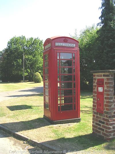
A cast-iron telephone box that was designed in 1935. (© NCC)
Hall Farmhouse (NHER
16722) is a 16th or 17th century timber framed house with a jettied first floor. Gelham Lodge (NHER
16723), Church Farmhouse (NHER
16724), and Glebe Farmhouse (NHER
21229) all date to the 17th century. Manor Farm (NHER
16725), a large 17th century house, is reputed to stand on a medieval moated site. The barn was originally a house or other domestic building associated with the farmhouse, and has a 17th century pedimented doorway. Park Farm (NHER
14296) dates to the 17th century and was substantially altered in the 19th century. The stables and a wagon lodge were built in the early 18th century, and were designed as eyecatchers to be viewed from the Hall. Station Farm (NHER
14297) is an early 18th century farmhouse that was enlarged in the early 19th century. Carleton Bridge (NHER
16721) has three arches and a carved coat-of-arms of the Wodehouse family bearing the date 1815. Green Farm (NHER
44292) was built in the mid 19th century in the Gothic Revival style. In the late 19th century the Wodehouses built several estate cottages within the parish on The Green and Station Road (NHER
44289 to
44291).
Sarah Spooner (NLA), 20 April 2006.
Further Reading
Brown, P. (ed.), 1984. Domesday Book: Norfolk (Chichester, Phillimore)
Mills, A.D., 1998. Dictionary of English Place-Names (Oxford, Oxford University Press)
Pevsner, N. and Wilson, B., 1997. The Buildings of England: Norfolk 2: North West and South (London, Penguin)
Rye, J., 1991. A Popular Guide to Norfolk Place-names (Dereham, Larks Press)
Williamson, T., 1998. The Archaeology of the Landscape Park: Garden Design in Norfolk c1680-1840 (BAR British Series No 268)