This Parish Summary is an overview of the large amount of information held for the parish, and only selected examples of sites and finds in each period are given. It has been beyond the scope of the project to carry out detailed research into the historical background, documents, maps or other sources, but we hope that the Parish Summaries will encourage users to refer to the detailed records, and to consult the bibliographical sources referred to below. Feedback and any corrections are welcomed by email to heritage@norfolk.gov.uk
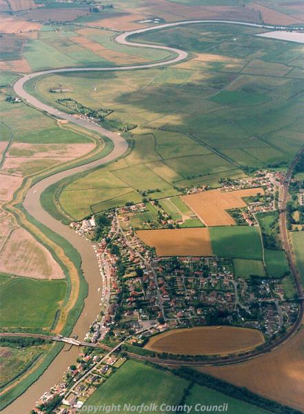
Reedham is an irregularly shaped parish in the southeast of Norfolk, in the Broadland local government district. The parish contains the village of Reedham and the Reedham marshes in the easternmost section. Drainage channels, which criss-cross the southern and eastern parts of the parish, heavily mark the land. The name ‘Reedham’ derives from the Old English for homestead by the reeds, or reed meadow, an appropriate appellation considering the surrounding landscape.

Aerial photograph of Reedham. (© NCC)
A small number of objects from the early periods of human occupation have been recovered. These are number two Neolithic worked flints (NHER
10415, NHER
10416), a polished stone axehead (NHER
10414) and a Bonze Age copper alloy palstave (NHER
10417).
Unfortunately no buildings or monuments survive from any of prehistoric periods, however there is a possible Roman structure (NHER 10418) just west of the church of St John the Baptist. It has been given various interpretations, including a pharos or Roman lighthouse. Pottery and metal work fragments have also been recovered. In addition a possible Roman camp (NHER 10421) has been suggested on Camp Hill, less than a hundred metres to the northwest.
Work by the Norfolk National Mapping Programme (Broads Zone) in 2006/7 has indentified the cropmarks of a coaxial field system, of later Iron Age to early Roman/Roman date, covering large tracts of the landscape. The existence of a large amount of re-used Roman stone in the fabric of St John the Baptist’s Church (NHER 10419), as well as the close proximity of all three sites, suggests that at least one site of Roman period occupation stood in this area. Despite this settlement evidence, a tile fragment (NHER 37517) and a coin (NHER 10420) are the only other objects from this period to be recovered in the parish.
Saxon finds are even more rare, limited to some pottery sherds from Camp Hill (NHER 10421). However, there is record of a church in the parish since the 7th century, and it is believe to have one of the longest Christian traditions in Norfolk. The current church of St John the Baptist (NHER 10419) does not have any identifiably Saxon origins, the buildings being almost exclusively constructed around 1100. The only external deviation from this is the large Perpendicular style tower, the result of bequests in the mid 15th century, and the roof, which had been thatched until a fire of 1981 resulted in the installation of today’s pantiles.
The only other possible site of Saxon origin is the earthwork of a probably Late Saxon to medieval saltern mound (NHER 42390) situated in the very northeast of the parish. A medieval saltern has been noted very close by (NHER 24208), and there are also a number of medieval to post medieval features such as drainage ditches (NHER 42448, NHER 49249), earthworks (NHER 49248, NHER 42389), and enclosures (NHER 42217).
Medieval finds are limited to a few pottery sherds (NHER 39794, NHER 24208), a coin (NHER 33939), and a few metal objects (NHER 28509, NHER 14100). Post medieval finds are even more limited, with only a few brick, pottery and tile sherds recovered at the site of a post medieval brickworks (NHER 16380) to the northeast of the parish.
Despite this lack of artefacts, a large number of post medieval buildings have survived to this day. This includes a small number listed by English Heritage as of particular architectural value; Witton Green Farm is perhaps one of the most interesting. It is an unusual brick house dating to the mid to late 17th century, set out on a variation of the lobby-entrance plan that was popular many years earlier. Also of interest is Old School House, which is a good example of early Victorian Tudor revival style school, built in 1830.

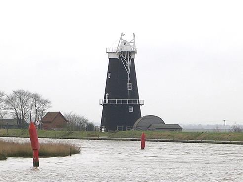
Berney Arms Mill, Reedham. (© NCC)
Reedham also retains two mill sites. Polkey’s Mill (NHER
10433), also referred to as Seven Mile House Mill, has unique surviving steam engine sheds. Next to this are the diesel pumps which replaced them in the 1940s, and all the buildings and machinery are in the process of being restored. Also surviving is Cadges Mill (NHER
10427), situated on the Reedham Marshes and consisting of a mid 19
th century three storey windpump that was part of a network working to drain the marshes.
Also related to the marsh is a duck decoy pond, probably dating to the 17th century (NHER 40379), as well as the stump of a former drainage wind pump brought down in a storm in 1890 (NHER 10428). Of note is the site of Reedham Hall (NHER 10432), which was built in 1557 and burnt down in 1750. Unfortunately no trace remains of the hall, which was rebuilt, or the lodges or avenue approach that originally occupied this site.
From more recent history the site of a World War One and Two searchlight battery (NHER 10425) is situated just 50m north of the Hall. Also recorded is the site of a World War Two crash site (NHER 33485), where two USAAF B17 bombers crashed in February of 1944, killing both crews.
Ruth Fillery-Travis (NLA), 28th March 2007.
Further Reading
Morris, J. (General Editor), 1984. Domesday Book, 33 Norfolk, Part I and Part II (Chichester, Phillimore & Co)
Mortlock D. P. & Roberts, C. V., 1981. The Popular Guide to Norfolk Churches No. 1, North-East Norfolk (Acorn Editions)
Pevsner, N., 1997. The buildings of England: Norfolk 1: Norwich and North-East (London, Yale University Press)
Rye, J., 1991. A Popular Guide to Norfolk Place Names (Dereham, The Larks Press)